 |
Ash Fork &
|
|
[HOME] [WESTERN AMERICANA GALLERY] [ROUTE 66 HOME] [ROUTE 66 WEST] [ROUTE 66 EAST]
|
Ash Fork &
|
|
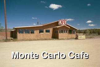
Monte Carlo & County Line Road |
|
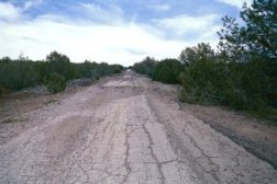
1932 Alignment of Route 66 winds through the Juniper trees about a mile from the old Monte Carlo Cafe. |
Route 66 leaves the pine country and drops down in elevation almost 1700 feet to the open slope and the plains beyond. There are many old alignments of Route 66 in this stretch between Williams and Ash Fork. As you drop down the grade towards Ash Fork an old alignment of Route 66 can still be seen on the left clinging to the hillside about halfway down, if you look close enough you can actually see where it crosses the Interstate and winds through the Juniper trees to the right. |
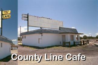
| This is the 1932 alignment of Route 66, if you were to follow this old road you would eventually end up at the Monte Carlo Cafe. This old cafe did not survive the nearby Interstate and shares the same fate as the County Line Cafe about a mile down the road. Jack Rittenhouse mentions a gas station and store being located at both these sites in 1946. When I first saw the County Line Cafe in the mid 1980's it was closed but in much better shape than it is today. Ash Fork is only two miles down the Interstate from here. | |
|
|
| They Said it Couldn't be Done | |
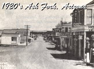
| Ash Fork was born in October 1882 when the Atlantic and Pacific Railroad established a siding at Ash Creek for the freighting companies of the area. They had been pressuring the railroad for a more convenient location than Williams. The building of the railroad in this portion of Arizona was no small feat. The railroad was laid out along the 35th Parallel or Beal's Old Camel Route amid dire predictions of failure. It was said that the right of way ran from nothing, through nowhere, to no place through some of the roughest country God ever made. A country where even mountain goats closed their eyes and walked sideways! The railroad ran a line south to Prescott in 1893, which eventually was completed to Phoenix two years later. This line was dubbed the "Peavine" due to all the curves and switchbacks necessary to build it through the mountains. People used to say it might take you all day to get to Phoenix, but you could see the country two or three times on that one trip. | |
|
Ash Fork's early years were typical of the wild old railroad towns of the era. The Population was a boisterous, devil may care crowd. Early travelers in the area noted that there were three hundred fifty saloons along two hundred miles of track. Over the years, as a more stable population moved in things quieted down somewhat. The Santa Fe Railroad built a Harvey House in Ash Fork in 1907. This elegant Harvey House, known as the Escalante, brought a touch of civilization to the rough frontier. Citizens of Prescott thought nothing of the fifty-mile drive to Ash Fork to dine at the Escalante. |
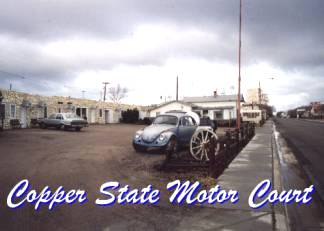
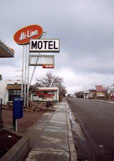
| During the 1920's with the call for better roads, horse drawn scrapers, steam rollers, and gravel lorries gouged out the roadbed through Ash Fork that would become Route 66. During the hey day of Route 66, motels, cafes, and gas stations sprang up to provide services to the traveler. In the 1940's troop trains made regular stops at Ash Fork that also added to the community's prosperity. Jack Rittenhouse mentions Ash Fork in his 1946 Guide to Highway 66 as having all facilities including the Copper State Motor Court. |
|
|
He also mentions that Ash Fork was a trading and supply center for the many cattle ranches in the area. After the war America was on the move and towns like Ash Fork prospered. In 1979 Interstate 40 bypassed the town and dealt what many considered to be the deathblow to the small community. Ash Fork didn't die though, and still provides services to the Interstate traveler. With the resurgence of interest in Route 66 Ash Fork's place in history is assured. Ash Fork also has the distinction of being the starting point for one of the longest stretches of unbroken Route 66 highway in existence today, Crookton Road. |
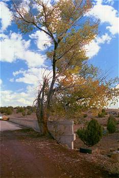
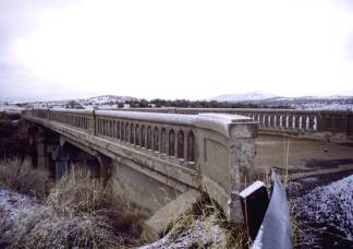
West of Ash Fork on a forgotten alignment of Route 66 you can find this old vintage bridge. It has been a long time since traffic crossed here on the way to and from Ash Fork as evidenced by this Cottonwood tree growing out of the bridge itself. For the observant traveler on Interstate 40 you can actually see this bridge off to the south of the "super slab" about a mile west of Ash Fork. To reach this bridge you will need to double back towards Ash Fork (if westbound) after taking the Crookton Road exit. Make a left turn at the stop sign and go over the Interstate. Make another left turn onto what appears to be the Interstate frontage road. This is actually old Route 66. Travel another two miles or so till you come to this bridge. Stay and reflect awhile here, it is well worth it. For here you can slow down and imagine another time in our history. For me it is poignant, I know my parents crossed this bridge on their way to California and a new life. I've been here before too, though I don't remember it. We would have crossed this bridge on our family vacations back in the 1950s. After your quiet time at this shadow of Route 66 you will need to go back to Crookton Road the way you came. This old alignment of Route 66 dead-ends at the Interstate a short distance beyond. There is no access to Ash Fork from here anymore. |
|
Route 66 and Crookton Road |
|
|
|
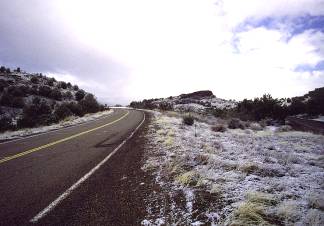
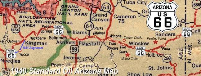
| Crookton Road is a beautiful 17-mile drive along the old highway into Seligman, Arizona. This is the essential Route 66 and a must drive for any fan of the old road. Nine miles down the road from Interstate 40 brings you to Crookton Overpass, a picturesque old concrete bridge from the Thirties that crosses over the tracks of the Santa Fe RR. The bridge is closed now, but stands as a monument to the hardy travelers of yesterday. Continuing on for another 8-miles through the rolling hills and plateau country of northern Arizona Route 66 finally enters the town of Seligman, a town that is proud of its Route 66 heritage. | |
Photographs taken March & May 2001
Click on an area or city of Route 66 on the map below to take a cyber tour of that section of the Mother Road |
|
|
NAVIGATION NOTE: Buckle up and hold on to your mouse! These pages are arranged like the map above. I have set up this site as if you were traveling from EAST to WEST, much like the Joad family in The Grapes of Wrath. You can click on the Route 66 shields to "travel" the Mother Road in either direction though. Clicking West Route 66 or East Route 66 will take you to the next town or area on the map in that direction. Or you can select any shield below to take you to that specific state. |
|
To Seligman |
To Williams |

© Copyright 2003 GRandall Web Design Service