 |
Trading Posts on
|
|
[HOME] [WESTERN AMERICANA GALLERY] [ROUTE 66 HOME] [ROUTE 66 WEST] [ROUTE 66 EAST]
|
Trading Posts on
|
|
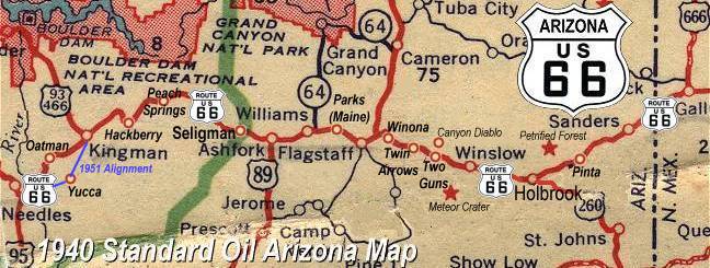
Treasures of the Open Road[Meteor City] [Meteor Crater Road] [Two Guns] [Twin Arrows] |
|
 |
Some of my fondest memories of road trips I took with my family when I was young involve those "tourist traps" along the highway. Along New Mexico and Arizona Route 66, Trading Posts were the order of the day. Those colorful outposts always had a wealth of treasures to enchant a young lad such as myself. Souvenir postcards of jackalopes, packages of rattlesnake eggs, cactus candy, tumbled stones, Indian goods made in Japan, and such, made it hard to choose what to buy. There was always something to take a picture of; concrete teepees, giant petrified logs, colorful billboards, and even a small zoo. All this could once be found along this stretch of Route 66. The coming of the interstate changed all that. I guess we got to be in too much of a hurry for amenities of the country we were passing through. |
| Meteor City just reopened spring 2001, but Two Guns and Twin Arrows are closed now. These Trading Posts managed to hang on until just recently. I suppose as the speed limits went up on I-40 the number of travelers who stopped went down. | |
Meteor City Trading Post, Arizona |
||
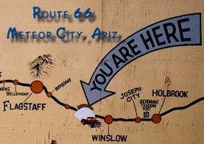 |
Going west on I-40 from Winslow you will see Meteor City. The Trading Post, located on the frontage road that is actually a part of old Route 66, has recently been reopened. | 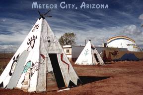 |
| This is a real vintage trading post. It was built in 1938 and has seen a lot of the Mother Road in that time. The distinctive dome was built in 1979 and can be seen for miles along this stretch of Route 66 (now I-40). I was first here in November, 2000 and the trading post was closed. There was a "For Sale" sign on the front door. I did take a this picture of the famous Route 66 map. I'm glad I did as this original "World's Longest Map of Route 66" was painted by Bob Waldmire, noted Route 66 artist and has since been covered up. The new owners of the Meteor City Trading Post have a new map now. This map was painted by Route 66 volunteers in 2002. | ||
 |
Great News!!! The Meteor City Trading Post reopened spring 2001 with new owners Richard and Ermila Benton. If you are in the area please stop by and support our Route 66 businesses. | |
Route 66 and Meteor Crater Road |
||
| Meteor Crater was formed about 20,000 years ago from a meteor impact. It is well worth the side trip to view this natural wonder. Route 66 travelers felt the same way as this site was listed in Jack Rittenhouse's Route 66 Guidebook published in 1946. | ||
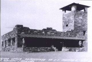 |
Meteor Crater ObservatoryBuilt by D.M. Barringer during the hey-day of Route 66, the view from the observation tower was disappointing. I'm sure the Observatory was located this far from the impact crater because it was right on Route 66 and could lure travelers in. "Easy Off - Easy On" even back then. For 25 cents one could view the crater through a telescope, and if the weather was clear - actually see it! |
|
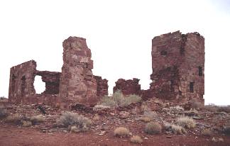 |
Observatory ruins and an old Route 66 era car can still be seen on the old highway about a half mile from the turnoff to Meteor Crater. | 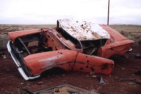 |
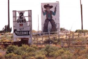
Don't Bother Stopping at Two Guns! ~ 2001 |
||
|
In 2001, you
were going to see all you are going to see of Two Guns as you drove by on I-40. The whole
area was fenced off and posted. Visitors were definitely not welcome here. The name Two Guns is as wild west a name as you will find out here. Believe it or not, it actually comes from the original inhabitant of the area, a wild, violent individual called "Two Gun" Miller. It is said that this eccentric hermit lived in a cave in nearby Canyon Diablo and was hostile to visitors. Apparently his spirit lives on in Two Guns by the way things were just a couple of years ago. |
|
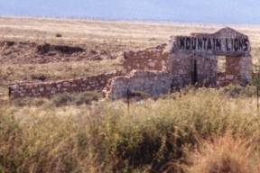
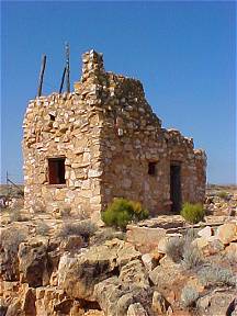
| In 2001 you needed a good pair of binoculars or a good telephoto lens on your camera to explore Two Guns. Just west of the closed gas station and campground you could still see stone ruins left over from the heyday of Route 66. Tourist stops like the Apache Caves and Trading Posts lured the Route 66 traveler to stay awhile in Two Guns once. There was even a small zoo located here for the pleasure of the tourists who came through. All that is left of them are the stone ruins along the rim of Canyon Diablo. It was at this point that Route 66 crossed Canyon Diablo. |
|
|
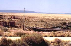 |
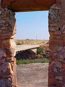
If you looked closely with a good pair of binoculars you could still see the old Route 66 Bridge that crossed the canyon that gave early explorers such a problem. The canyon was named by Lieutenant Whipple during the 1853 35th parallel survey. The canyon presented such an obstacle to the expedition that they had to go 25 miles out of their way to cross it! Lieutenant Beale with his Camel Corps in 1857 had the same problem in crossing the canyon. Today, I bet most people don't even realize they are crossing a notorious canyon as they speed down the interstate. | |
Two Guns is For Sale ~ 2003 |
||
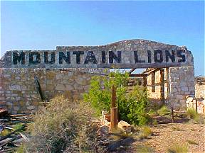
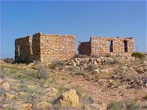
|
Because Two Guns is now for sale the posted signs were down and the gate was open. I suppose this was to allow prospective buyers the opportunity to inspect the property. It also allowed Route 66 Road Wanderers an opportunity to finally get close-up pictures of some of the fascinating ruins that were to be found all along the rim of Canyon Diablo at Two Guns. Though it was a windy May day I couldn't resist the opportunity to finally inspect Two Guns up close. Though my time was limited and the wind was blowing with gale force intensity I was going to do some photographic exploring! I hope you enjoy these close ups photos of a real Route 66 treasure. | |
My visit at Two Guns was great, though I almost got blown into Canyon Diablo more than once by a sudden gust of wind while taking pictures. I think the highlight was when I drove across the old Canyon Diablo Bridge with my car. It was a reflective moment for me. Once a nation on the move crossed this very bridge! I could easily spend days here exploring. This must have been on massive tourist stop on old Route 66 once. The stone ruins attest to the fact that this once was no small operation. The fate of Two Guns is uncertain, I only hope whomever buys the property will respect the historical significance of the area. |
|
|
|
|
|
Take a trip from Two Guns on Route 66 to a colorful ghost town... |
||
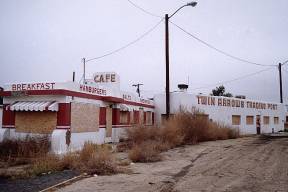
Twin Arrows Trading Post, Arizona |
|
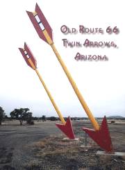 Another casualty of the Interstate is located a few miles east of Winona where old Route 66 started to climb into the wooded foothills of the Colorado Plateau. Twin Arrows Trading Post, just recently closed, with the price of gas frozen at $1.39 a gallon, and the last hamburger sold. |
 |
|
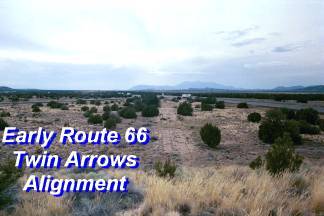
Where Old Route 66 & I-40 Meet at Twin ArrowsIf you look closely at the picture to the left you can see the old alignment of Route 66 cutting a path through the desert where it will intersect I-40 in the distance. This is the earliest alignment of Route 66 in the area, this old section eventually ended up at the old Padre Canyon Bridge (see below). This section is located between the Twin Arrows Frontage Road and I-40. |
Padre Canyon BridgeThe old 1920's alignment of Route 66 crossed Padre Canyon near Twin Arrows over this unique concrete bridge. You cannot see the bridge from the Interstate. This 1914 Padre Canyon Bridge was the first Route 66 Bridge in the Twin Arrows area. A second bridge was built further south in 1937 and was destroyed when the Interstate was built. The footings from the second bridge can still be seen in Padre Canyon under the modern west bound I-40 bridge. |
|
Take a Trip from Twin Arrows and explore the Padre Canyon Bridge... |
| In this day and age of chain restaurants, strip malls and designer shops we are in danger of losing the individual establishments typical of old Route 66. Thankfully, here and there one can still find those little cafes, mom and pop stores, and motor courts. They are getting harder to find though. Hopefully we as a people will rediscover what our parents and grandparents knew and not let these pieces of Americana slip away. The increasing interest in Route 66 and its history may help preserve our heritage for future generations. Thanks to all of you, the kindred spirits of the Mother Road, Route 66 still lives on. |
Photographs taken November 1956, November 2000, July, September 2001 & May 2003
Click on an area or city of Route 66 on the map below to take a cyber tour of that section of the Mother Road |
|
|
NAVIGATION NOTE: Buckle up and hold on to your mouse! These pages are arranged like the map above. I have set up this site as if you were traveling from EAST to WEST, much like the Joad family in The Grapes of Wrath. You can click on the Route 66 shields to "travel" the Mother Road in either direction though. Clicking West Route 66 or East Route 66 will take you to the next town or area on the map in that direction. Or you can select any shield below to take you to that specific state. |
|
To Flagstaff |
To Winslow |

© Copyright 2003 GRandall Web Design Service