|
Devil's Elbow Area |
|
[HOME] [WESTERN AMERICANA GALLERY] [ROUTE 66 HOME] [ROUTE 66 WEST] [ROUTE 66 EAST]
|
Devil's Elbow Area |
|
|
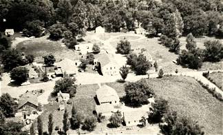
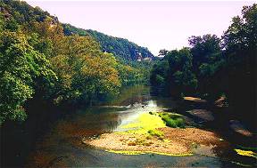
Devil's Elbow, Missouri is one of the prettiest places on Route 66 in my opinion. There's a lot of history in this area of Route 66 in the Ozarks. The community got its start back in 1870 and was named for a particularly bad bend in the Big Piney River. Lumberjacks would float logs down the river and they would seem to always jam at this place. There was a large boulder in the river at this point that some lumberjacks swore was put there by the devil himself just to cause them grief. The community of Devil's Elbow is a like a page out of history. Here the decades slip away to another, simpler time, far from the noise and bustle of the Interstate. During the 1930s and 1940s Devil's Elbow was a resort community with cabins, canoes, and the famous Munger Moss Sandwich Shop of course. | |
|
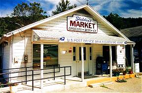
The old Miller's Market and Post Office in Devil's Elbow was built in 1954. Today Philip Sheldon owns it. | |
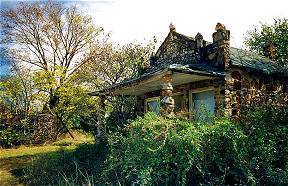
| Charles McCoy built McCoy’s Store and Camp in 1941 to serve as Devil's Elbow's store. Rooms in the upstairs were rented out to travelers on old Route 66. | 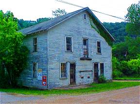 |
|
|
|
|
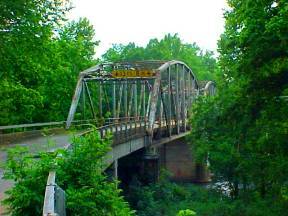
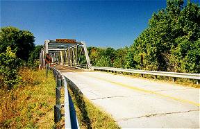
| The beautiful old steel truss bridge crosses the Big Piney River at Devil's Elbow and dates back to the early days of Route 66. | ||
|
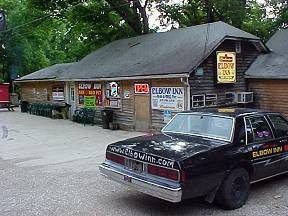
The historic Elbow Inn dates back to the 1930s when it was the Munger Moss Sandwich Shop. Built by Nelle & Emmett Moss, the business was moved to Lebanon in 1946 when old Route 66 was realigned through Hooker Cut. This was once the deepest rock cut in America. When Route 66 was realigned in the 1940s through here it bypassed Devil's Elbow. | |
| Ramona Lehman, present owner of
the Munger Moss Motel in Lebanon, Missouri adds more to the history of this fascinating
area, "The Munger Moss originally was a barbecue place located on the Big Piney River
at Devil's Elbow, just east of Ft. Leonardwood, MO. It was started in the late 30's or
early 40's. A couple by the name of Munger ran it, Mr. Munger passed away, and Mrs. Munger
remarried a gentleman by the name of Emmett Moss. Hence Munger Moss Sandwich shop came to
life.""It
became very famous for its' barbecue recipe, and was known up and down Highway 66 as such.
Don't know for sure when the Hudson's took over the barbecue place, but do know it was war
years. The tale is that it took all day for a truck loaded with an airplane to go from the
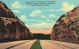
bottom of the hill to the top out of Devil's Elbow. That was when they started cutting
down the big hill that you see in the postcards known as the Hooker Cut."
"When that 4-lane road opened up, the business at the Munger Moss Barbecue died. The Hudson's wasted no time. They started looking for a suitable place to relocate too. Highway 66 was booming, what with the war and travelers. Just east of Lebanon was a 4-acre parcel of land with a restaurant and filling station. The restaurant was known as Chicken Shanty. Across the road was Green Gables (four cabins) and next door was the Rock Court. The Hudson's were able to purchase this land late summer of 1945. They brought the barbecue recipe with them - so a new Munger Moss Barbecue came to Lebanon." |
||
|
|
|
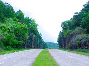
The Hooker Cut from a 1946 Post Card (Left) and Hooker Cut in 2003 (Right) |
||
| If you are going west on Route 66 towards Lebanon the Mother Road winds through the beautiful Ozark Mountains through the small communities that add so much color to an already colorful place. The communities of St. Robert, Waynesville, Buckhorn, Laquey and Hazelgreen all have wonderful examples of Route 66. Most of these communities depended on the tourist trade. Numerous cabins and resorts dot the area. | ||
 |
This old Rock Store in Waynesville is all that's left of the Hillcrest Groceries and KanOTex Gas Station. Built of native rock by Vern Smith in the 1930s it served Route 66 travelers for decades. Today it is a unique reminder of old Route 66 through the Ozarks. |
|
An old steel truss bridge outside of Hazelgreen reminds one of the days when this road was America's Main Street. |
 |
|
Photographs taken September 2002 and June 2003
Click on an area or city of Route 66 on the map below to take a cyber tour of that section of the Mother Road |
|
|
NAVIGATION NOTE: Buckle up and hold on to your mouse! These pages are arranged like the map above, from the western state border to the eastern state border. I have set up this site as if you were traveling from EAST to WEST, much like the Joad family in The Grapes of Wrath. You can click on the Route 66 shields to "travel" the Mother Road in either direction though. Or you can select any shield below to take you to that specific state. |
|
Lebanon and the
|
To Route 66
|

© Copyright 2003 GRandall Web Design Service