|
The
|
|
[HOME] [WESTERN AMERICANA GALLERY] [ROUTE 66 HOME] [ROUTE 66 WEST] [ROUTE 66 EAST]
|
The
|
|
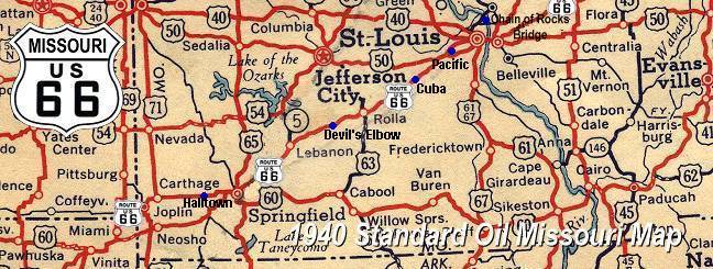
| As you head west out of St. Louis you will find that Route 66 has been chopped up by Interstate 44. There are small stretches of drivable Route 66 here and there and a good guide or map is essential for your explorations. Two alignments of Route 66 leave St. Louis. The old 1926 – 1933 alignment leaves St. Louis on Manchester Rd and rejoins Interstate 44 at Gray Summit. If you follow Interstate 44 out of St. Louis you will be following the 1933 – 1976 alignment of Route 66. The Route 66 State Park and old Times Beach townsite can be reached from Eureka. One word of advice though, pay attention to the exit sign for the Route 66 State Park. When I came through here last June 2003 I fully planned on stopping at the park. Traffic was heavy and road construction made things rather confusing for me. Needless to say I missed the exit. I though about turning around at Eureka but one glance at the backed up eastbound traffic (it was backed up many miles - all the way to Interstate 270 in St. Louis) made me reevaluate my plans. Oh well, next time I guess. I continued down the Interstate where I would rejoin Route 66 at Pacific. | ||
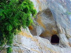 |
Pacific, Missouri started as a railroad town. The Pacific Railroad Company laid out the town in 1852. You could say it was the end of the line for the Pacific Railroad too for awhile. Due to financial problems the building of the line stalled at Franklin, the original name of Pacific in from 1852 through 1854. When the post office opened it was found that the name of Franklin was already taken so a new name was needed. Ever optimistic, the town chose Pacific as the new name. After all the Pacific Ocean was the hoped for destination of their railroad. Pacific is also a mining town. Silica mining started in Pacific in the 1870s. The fine silica sand found in the bluffs around town was used to make fine glassware. At the western end of town you can still see some of the silica mine "caves" along the highway. The widening of Route 66 in 1932 cut sheared back the bluff exposing these tunnels. | |
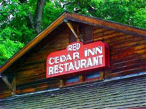
| Perhaps the best known attraction in Pacific is the Red Cedar Inn. The Red Cedar Inn was built because of Route 66. James Smith I and his brother Bill built the restaurant in 1934 with logs cut from the family farm and hauled to the site on a Ford Model "AA" one ton truck. In 1935 the bar room was added. The Red Cedar Inn is truly a family business. In 1935 James Smith II, manager of operations, hired 19 year old Katherine Brinkman as a waitress. Well as things turned out James II and Katherine fell in love and were married in 1940. In 1944 James bought the business from his father. Together with their children Ginger and James III they ran the business until James II retired in 1972. |
|
|
| In 1987 the Red Cedar Inn was reopened to serve the travelers on old Route 66. Ginger and James III along with mom's help and temporary business consultant Wes Karna brought this famous landmark back to life. Wes Karna agreed to help with the venture for 6 months but something happened - he fell in love with the old restaurant. Today Wes Karna is still with the James Smith family as managing partner and cook! What a jolly person he is too. His positive attitude and genuine concern for the satisfaction of his customers infected me. Ginger, James III and Wes had a vision and they went for it. It can't get better than that! The Mother Road is in good shape at Pacific, Missouri. | ||
 |
 |
|
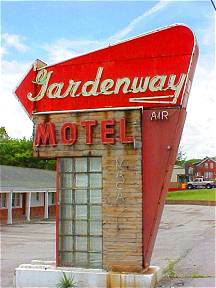
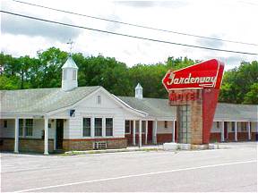
| Route 66 winds its way out of Pacific and passes many relics from the hey-day of the Mother Road. The Gardenway Motel is now closed but at one time it was an ultra modern facility built at the western terminus of the famous Henry Shaw Gardenway, a park like section of old Route 66. The sign is a wonderful throwback to the days of the family vacations and Route 66’s Golden Era of travel. | ||
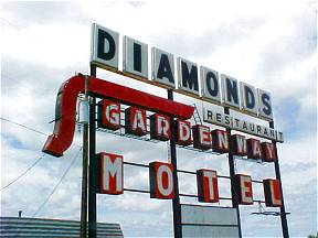 |
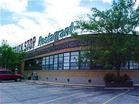
Not far from the Gardenway Motel is the lonely Diamonds Restaurant sign. This is the "new" Diamonds and unfortunately it is closed now. The Restaurant moved to this location along Interstate-44 in 1967 and took its sign with them. The original Diamonds is located two miles away in Villa Ridge and is the Tri-Country Restaurant and Truck Stop now. The Diamonds Restaurant was started by Spencer Groof to service the early Route 66 traveler. Once it was the place to stop on Route 66 and was billed as the "World’s Largest Roadside Restaurant." The Diamonds was originally built in 1927 then again in 1948 after a fire destroyed the original building. The building was built in the shape of a baseball diamond hence the name. | |
The original Diamonds Restaurant building is now the Tri-State Truck Stop and Restaurant. This was built in 1948 when the original 1927 building burned with a fire so fierce that it shut down Route 66! |
|
|
|
|
|
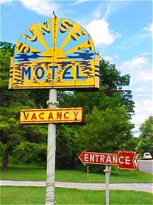
| Less than two miles west of the Tri-County Truck Stop (Old Diamonds Restaurant) is the now closed Sunset Motel. It was built in the 1940s and advertised 12 units, 12 baths, Panel Ray Heat, Beautyrest Mattresses, air conditioning and quiet. I can attest to the fact that it is indeed very quiet there today. | ||
Stanton, Missouri |
||
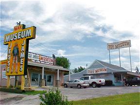
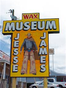
| From Pacific Route 66 continues on through the town of St. Clair then into Stanton. Stanton was named for Peter Stanton who operated a powder mill at this site in the 1850s. I wonder if Peter knew Jesses James? Stanton, Missouri is home to the celebrated Meramec Caverns and a purported hideout of the famous outlaw. The caverns were opened commercially by Lester Dill in the 1930s and had parking for 300 cars, electric lighting and a large dance floor. I have yet to stop at the caverns, my next trip through the area I will. There are some other interesting attractions at Stanton too. The Jesse James Wax Museum and the Stanton Toy Museum are but a few along this stretch of Route 66. |
|
|
|
||
Photographs taken June 2003
Click on an area or city of Route 66 on the map below to take a cyber tour of that section of the Mother Road |
|
|
NAVIGATION NOTE: Buckle up and hold on to your mouse! These pages are arranged like the map above, from the western state border to the eastern state border. I have set up this site as if you were traveling from EAST to WEST, much like the Joad family in The Grapes of Wrath. You can click on the Route 66 shields to "travel" the Mother Road in either direction though. Or you can select any shield below to take you to that specific state. |
|
To the Cuba
|
To St. Louis |

© Copyright 2003 GRandall Web Design Service