|
Springfield, Missouri |
|
[HOME] [WESTERN AMERICANA GALLERY] [ROUTE 66 HOME] [ROUTE 66 WEST] [ROUTE 66 EAST]
|
Springfield, Missouri |
|
|
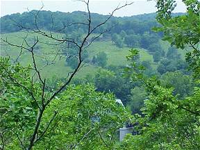
Springfield is the "Queen City of the Ozarks" and is located in the heart of these beautiful mountains. This is a modern city that has grown out to meet Interstate 44. But once Route 66 passed through its very heart. There are still remnants of the old road in evidence along the old alignments of the Mother Road if one looks for them. During the hey-day of the Mother Road the Ozarks were a nation's playground. Today they have lost none of their charm. The green forested rolling hills may not qualify as true mountains in my "Colorado western mind," but they are beautiful and lush non-the-less. I have images of sitting around a campfire with friends spinning tales of Indians and outlaws deep within the hollows of the Ozarks. | |
| The town of Springfield was founded in 1829 when the first settler arrived in the area. Two years later a school was built and the town was well on its way. A Civil War battle and deadly duel right out of the pages of the old west happened in Springfield. The Civil War Battle of Wilson’s Creek happened August 10, 1861 and claimed the lives of 2,500 men. These Civil War casualties, both Union and Confederate, are buried in Springfield. Along about 1865 Wild Bill Hickok visited Springfield and killed Dave Tutt in a bloody duel over a gambling misunderstanding. Later he ran for town marshal but lost the election. Lots of history in this town. One famous business that called Springfield home was called Campbell’s 66 Express and their trucks, whose sides were blazoned with "Snortin’ Nortin" the galloping camel who was just "Humpin’ to Please" once was a familiar site all up and down the highway. For more than 65 years "Snortin’ Nortin" epitomized Route 66 in the heartland but sadly it closed and ceased operations in 1986. Today a couple original trucks and trailers can still be seen at Henry’s Rabbit Ranch and Route 66 Emporium in Staunton, Illinois. | ||
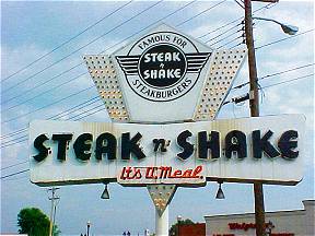
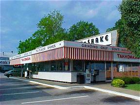
A classic example of the early fast food chains is located in Springfield. The Steak & Shake on the corner of National Ave. and St. Louis St. in Springfield has been serving satisfied customers since 1962. |
|
|
|
The original chain was founded by Gus Belt in 1934 and started in Normal, Illinois. It has come a long way since then and Steak and Shakes can be found all through the mid-west. This Steak and Shake is one of the few left with the "old" original design. Their motto is still the same though, "In Sight it Must Be Right" refers to the grills being visible to the customer. This way the customer can watch his food being cooked to insure it’s done right. | |
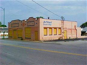
| Across the street from this 1962 Steak & Shake is an old Route 66 business, now closed. Once this was the home of Otto’s Restaurant and was a popular stopping off place for the highway traveler on Route 66. Unfortunately, this old Route 66 building is not long for the world. It has been slated for demolition to make way for new urban development. I took this picture in June 2003 and there is a very real chance that Otto’s is already a Route 66 memory. |
|
|
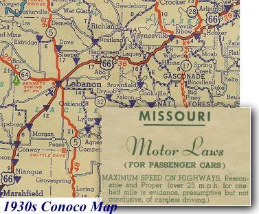 |
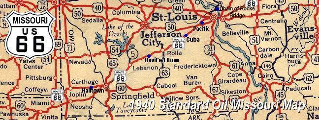
This 1930s highway map of Missouri shows Route 66 in the heart of the Ozarks. I think the speed limits for passenger cars is a hoot. |
|
Route 66 West of Springfield |
||
|
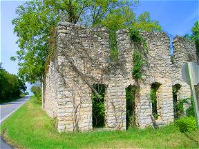
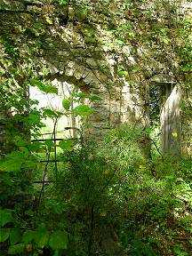
About four miles east of Halltown Route 66 passes through the remains of Plano. What truly stands out about Plano is the ruins of an old stone two story building on the right hand side of the road as you drive west. When I first saw the building my mind raced at what it could have once been. I’m sure it predates Route 66 by the style of architecture. I could only speculate on what its function could have been. I would have bet it was an old road house/tavern or hotel. In truth it once was a casket factory and mortuary in the early days before Route 66. Later it was a furniture store. | |
| Who built it, how long it served the area, and the people that frequented or made it their last stop before eternity - as the case may be – now are shrouded in time. All that remain are the walls; the roof and floors are gone. Inside the ruins the trees, shrubs and plants have reclaimed their domain. It is silent and still. I glanced around this hidden garden within the ruined walls. It was otherworldly here; a place apart from this world yet still tied down to this world. A faint breeze rustled the leaves within the inner sanctum of its walls and startled me with its sound. Was it really the sound of the breeze against leaves? Or is it perhaps the whispers of those that passed this way so very long ago - wondering at whom this strange interloper was that dared disturb their quiet world? |
|
|
Photographs taken June and September 2003
Click on an area or city of Route 66 on the map below to take a cyber tour of that section of the Mother Road |
|
|
NAVIGATION NOTE: Buckle up and hold on to your mouse! These pages are arranged like the map above, from the western state border to the eastern state border. I have set up this site as if you were traveling from EAST to WEST, much like the Joad family in The Grapes of Wrath. You can click on the Route 66 shields to "travel" the Mother Road in either direction though. Or you can select any shield below to take you to that specific state. |
|
To Halltown |
To Lebanon and the
|

© Copyright 2003 GRandall Web Design Service