|
Meet the Old West at
|
|
[HOME] [WESTERN AMERICANA GALLERY] [ROUTE 66 HOME] [ROUTE 66 WEST] [ROUTE 66 EAST]
|
Meet the Old West at
|
|
|
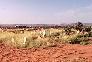
I truly enjoyed my experience at Montoya. Even before I came into what's left of Montoya I passed its cemetery on my left as I headed west. I was suddenly struck with images of Clint Eastwood and the Good, Bad and the Ugly. This was truly a southwestern cemetery. It was a mingling of cultures, Spanish, Indian and Anglo. Past the cemetery as I approached the town I saw an old ruin of what must have been a Route 66 watering hole once. This was the Route 66 Montoya. | |
| A short distance down the road was an old store and gas station, now closed down for years. But there was an even older town visible across the tracks on my right. You could see its faded glory in its clap board and stone ruins peeking over the railroad bed. To me this looked like the epitome of an old west cattle town. It looked like I was going to do some exploring from two very different eras here. I decided to check out the old town first, then come back to Route 66 later. |
|
I turned right, crossed the tracks and turned back the clock one hundred years... |
||
|
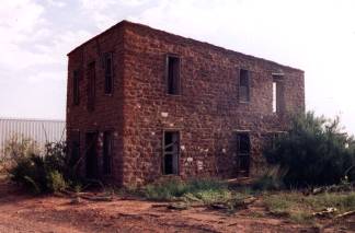
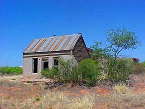
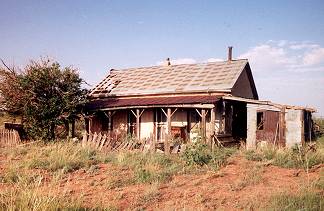
Montoya got its name in 1902 when the railroad arrived. But there was the cattle town of Rountree here before the railroad. This was the old town I was exploring now. I took some pictures and wandered the quiet site. What stories must lie hidden among the tumbleweeds and discarded tin cans? I enjoy these lonely, silent places. It is a time for reflection and wonder for me. It is sad too. An old two story stone structure indicates that this town was built to go the distance, it was built for permanence. The old stone structure was built by Sylvan R. and Maria Ignacia Hendren in the early 1900s and was affectionately called "Casa Alta" by the residents of Montaya. | |
| The abandoned houses are haunted by the human drama that must have gone on here once. Wandering in the midst of these ruins I can't help but think that they represent lost dreams and failed hopes. The railroad and then Route 66 kept this town alive once. Now all that is here are memories. I left the old town and crossed back over the tracks into the Twentieth Century and Route 66. | ||
|
|
|
|
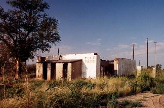
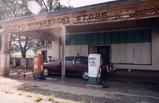
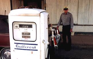
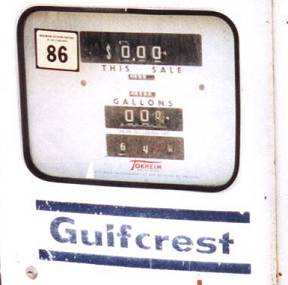
Back along Route 66 I stopped at the now closed Richardson's Store. The gas pumps under the canopy were frozen in time with a price of 64 cents a gallon. Richardson's Store is not completely dead though. The back part of the building is still used as a post office of sorts for the area residents. And the store itself is under the watchful eye and protection of Charles B. Dominguez. I had the sincere honor of meeting the man and learning a little more about Montoya from him. It was just shear luck that I ran into him as he was getting ready to go to town (Tucumcari) for supplies. I wandered over to introduce myself to Charles and ask permission to take some pictures of the gas pumps. | |
| One thing led to another and pretty soon I was hearing tales of another time. Richardson's Store closed in the mid 1970s and when the owner passed away Charles, a family friend, was asked to look over the property for a few weeks. It has been ten years now that he has performed that chore. He told me that the store was locked up with everything left on the shelves from the day it closed decades ago - except the perishables of course he added with a smile. |
|
|
|
"Until a few months ago the cigarettes were still in there too. Finally got rid of them. They were well aged and pretty strong." he laughed. " I noticed you over in the old town," he added. "Did you get to that building over there?" he pointed to a ruin consisting of a three walls and pile of lumber. "That was the bank once. Course it closed in 1929 after the crash, became a general store after that." We talked for awhile under the shade of the old canopy at Richardson's Store. The years melted away as I listened to Charles. His family came from this area. His brother was buried in the cemetery outside of town. He had lived in Montoya all his life. |
I mentioned Route 66 and my interest in the old road. "Yes
this place was busy once," he said. He pointed to the cracked asphalt of Route 66,
"I remember it would take me at least a half hour to cross that road back during
WWII. Yep, there was that much traffic then. After the war there were people driving that
road at all hours of the day and night. You wouldn't know it now by looking at would
you?" Route 66 stretched out from us in either direction, silent and empty. All too
soon it was time for both of us to get back on the road. He was heading east to Tucumcari
and I was heading west down Route 66 but Charles Dominguez had made my day. To me this is
what the old highway is all about. It's the people and their stories that bring Route 66 to life for me. |
Photographs taken September 2002 & May 2003
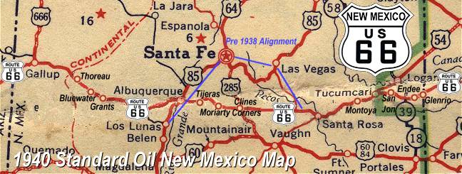
Click on an area or city of Route 66 on the map below to take a cyber tour of that section of the Mother Road |
|
|
NAVIGATION NOTE: Buckle up and hold on to your mouse! These pages are arranged like the map above, from the western state border to the eastern state border. I have set up this site as if you were traveling from EAST to WEST, much like the Joad family in The Grapes of Wrath. You can click on the Route 66 shields to "travel" the Mother Road in either direction though. Or you can select any shield below to take you to that specific state. |
|
To Newkirk |
To Tucumcari |

© Copyright 2003 GRandall Web Design Service