|
Santa Fe
|
|
[HOME] [WESTERN AMERICANA GALLERY] [ROUTE 66 HOME] [ROUTE 66 WEST] [ROUTE 66 EAST]
|
Santa Fe
|
|
|
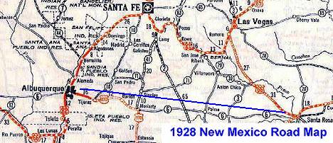
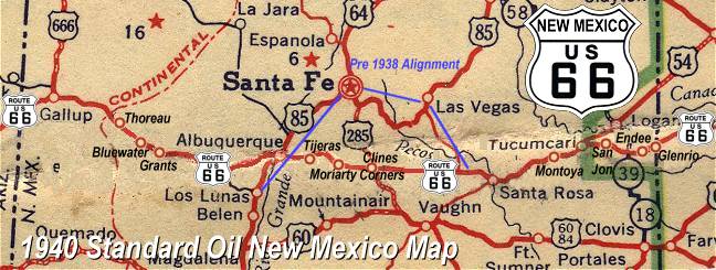
| When Route 66 was first laid out in 1926, everybody knew it would go through the capital of New Mexico and indeed it did. Route 66 followed the Old Pecos Trail from Santa Rosa through Dilia, Romeroville and Pecos to Santa Fe. From Santa Fe it went over La Bajada Hill and down into Albuquerque. That was the way it was aligned and constructed and that was the way it was supposed to stay - forever. But it didn't. But why was it moved? In 1927 the then governor of New Mexico, Governor Hannett lost the re-election. Hannett blamed this on the politicians in Santa Fe. In one great last act of defiance before the new governor was sworn in he vowed to get even with this Santa Fe ring. He had until January to institute his revenge. And he did! He decided the best way to get even was to blade an alternate route to Albuquerque and bypass Santa Fe altogether. This new alignment would bypass the Santa Fe businesses and Santa Fe politicians. It was a race against time. With no time off for the workers, including Christmas, he had to build a road through the virgin landscape fighting the elements, the vegetation and anybody and anything that got in his way. There was no time to buy the right a way so the road cut across both public and private land with no regard for the ownership. Though the road was not quite finished by the time the new governor took office in January, bad weather conditions prevented him from contacting the work crews to stop the project. By the time the new governor met with the work crews it was too late. The new road had been finished and cars were already driving the new route that cut off more than 90 miles of driving distance between Santa Rosa and Albuquerque. Santa Fe had been bypassed! The new alignment was really a better route from an engineer's standpoint. It was a more direct route that cut out some treacherous road conditions. It was also quite a bit shorter. By 1938 when Route 66 was paved this segment was officially designated Route 66. This is the route that would be followed by the new Interstate years later. Now you know the whole story! |
Santa Fe ~ Capitol of New Mexico |
||
|
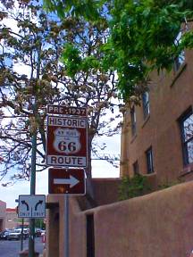
Though Santa Fe lost its place on Route 66 in 1938, it remains one of the most picturesque cities in New Mexico, steeped with the mystery and romance of a colorful history. Founded in 1610 on the ruins of an abandoned Tanoan Indian village, Santa Fe has been a capitol for nearly four hundred years making it the oldest capitol in the United States. The Palace of the Governors was constructed between 1610 and 1612 and is the oldest government building in the country. Once this town was the end of the old Santa Fe Trail (a portion of which was shared by Route 66 between 1926 and 1937), an exotic destination luring the earliest Anglo explorers and traders west. The Santa Fe trail was the earliest trade route linking the American frontier back east with the far west. The Santa Fe Trail would serve as part of the southern route to California during the gold rush of 1849, followed by the railroads in the 1880s and in turn the old trail would inspire the building of a national highway that would later become Route 66. | |
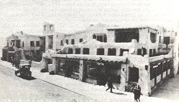
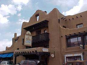
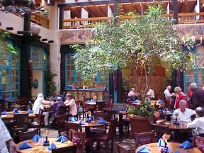
The La Fonda Hotel |
||
The famous La Fonda Hotel in 1925. Headquarters for the Santa Fe Railroad Indian Detours and stopping off place for early Route 66 travelers. The La Fonda is still in operation today and is one of Santa Fe's most celebrated historical icons. |
|
|
|
|
|
| There has been an inn or fonda on this corner next to Santa Fe's historic plaza since 1610. Throughout the days of the Santa Fe Trail, the California Gold Rush, and New Mexico territory travelers have come to this corner in Santa Fe for lodging and rest. The last inn on the corner before today's La Fonda was destroyed in 1919. The present day La Fonda was built on the site in 1920. After the business venture failed the Atchison, Topeka and Santa Fe Railroad acquired the hotel, which they then leased to Fred Harvey in 1926. From 1926 through 1969 the La Fonda was one of the famous Harvey Houses. During those early years the La Fonda served as headquarters for Fred Harvey's Indian Detours. Passenger would take the Santa Fe Railroad and disembark at the La Fonda for a touring car adventure into Indian Country. This service allowed cross-country rail travelers an opportunity to tour Southwestern attractions including Indian Pueblos, Indian Ruins, and even Carlsbad Caverns. It was a marketing ploy that was highly successful during the 1930s and 40s. | ||
|
|
|
The Native American and Spanish Colonial influence can be seen everywhere in Santa Fe. |
||
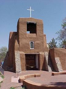
The Oldest Church in the United States |
||
|
Santa Fe is a fascinating town full of historical surprises around every corner. Across the street from the oldest house in the country is the San Miguel Mission which is the oldest church in the country. I was quite taken by its simple, yet intriguing lines. This was how I imagined and old Southwestern church should look. The facade that the visitor sees today was completed in 1955 after the last major restoration. This is perhaps one of the oldest sections of Santa Fe as it is built on the ruins of an old Indian Pueblo from the around 1200 A.D. If Santa Fe had RR tracks back in the 1600s, this would have been the area known as "Across the Tracks" so to say. This was the Indian section of Santa Fe. The Spanish section was the Plaza and Palace of Governors of course. Tlaxcalan Indians from Mexico built San Miguel Mission in the early 1600s . It was used as the gathering place for the Pueblo Indians in the Pueblo Indian Rebellion of 1680. The church bell was rung to signal the assault on the Spanish that drove them out of the area for 10 years. | |
The church roof was burned and destroyed during the rebellion. General Diego de Vargas resettled Santa Fe and had a new roof constructed in 1694. Repairs to the church continued until 1710. From 1610 through 1862 Franciscan padres ran the church. In 1859 the Christian Brothers came into possession of the church. Under the direction of Bishop Lamy it expanded to include a school in 1887. |
||
Route 66 Side Trip to Haunted San Miguel: |
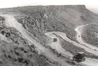
La Bajada Hill |
||
| La Bajada Hill, that very name struck terror in the hearts of early Route 66 motorists. It perhaps was one of the most challenging sections of Route 66 to found. It ranked right along with the old Gold Road and Sitgreaves Pass in Arizona. Travel back in the old days could be quite an ordeal and the La Bajada Hill was at the top of the list. Between the years of 1926 - 1932 this was Route 66. This road goes back a long way in time though, some 225 years in fact. Originally it had been part of the Camino Real de Tierra Adentro, or Royal Road to the Lands of the Interior, and ranks as the oldest European highway in the U.S. | ||
|
During the days of early Route 66 it intimidated motorists by its sudden 500-foot drop along a narrow, talus ridden, switch backed road that was hardly more than a trail blasted from rock. It is even said that enterprising Santa Feans would wait for timid motorists and offer to drive their cars down the grade for compensation. Convicts originally blasted and chiseled the road out of La Bajada Mesa between the years 1923 and 1924. The Fred Harvey company with their Indian Tours was instrumental in having several hairpins curves eliminated and the road widened in places to accommodate their new tour buses in 1925. When Route 66 was certified in 1926, La Bajada hill became part of the US highway system. | |
If you were to drive La Bajada Hill back in the late 1920s would
you have been a little intimidated by the sign the New Mexico State Highway Department put
up as a warning to motorists? The sign read: |
La Bajada Hill |
|
Click on an area or city of Route 66 on the map below to take a cyber tour of that section of the Mother Road |
|
|
NAVIGATION NOTE: Buckle up and hold on to your mouse! These pages are arranged like the map above, from the western state border to the eastern state border. I have set up this site as if you were traveling from EAST to WEST, much like the Joad family in The Grapes of Wrath. You can click on the Route 66 shields to "travel" the Mother Road in either direction though. Or you can select any shield below to take you to that specific state. |
|
To Albuquerque |
To Santa Rosa |

© Copyright 2003 GRandall Web Design Service