|
Old Arizona
|
|
[HOME] [WESTERN AMERICANA GALLERY] [ROUTE 66 HOME] [ROUTE 66 WEST] [ROUTE 66 EAST]
|
Old Arizona
|
|
| Arizona contains the longest single stretch of old Route 66 still remaining today. From Ash Fork to the Colorado River you can drive over 150 miles on the Mother Road. I was making this trip in March and the weather was very unsettled. While I was stopped in Seligman the dark clouds had started to roll in again. After I had left Seligman, I didn’t have far to drive before the sky seemed to fall down about me and the hills disappeared into a white shroud of mist and ice. Soon snow flurries danced around me, the visibility dropped to a couple hundred feet and I started to question the wisdom of driving old Route 66 during a winter storm. I only hoped the storm would quit soon. Then, as if in answer to my prayers, the elevation started to drop and the snow began to let up. Within a few more miles the road was clear and the snow stopped altogether. Soon I had left the winter wonderland behind. Before me old Route 66 wound its way over the hills and through the cedar trees as it followed the contour of the land. |
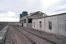
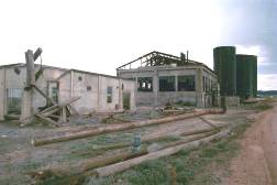
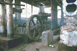
Pica Cross Over Station |
||
| 18 miles west of Seligman off in the distance I saw what looked like an old train station along the Santa Fe tracks. I pulled off Route 66 to investigate and found this old abandoned water station from the steam era of railroading, the Pica Cross Over Station. The steam locomotives have vanished from modern railroading, and this station has gone the way of Route 66 in so many ways. (May 2001) | ||
|
|
|
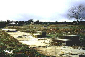
Hyde Park once a Route 66 Resort |
||
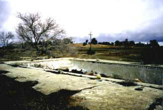
Hyde Park is now a playground for ghosts. |
 |
|
| Hyde Park was a small tourist camp located in the cool hill country of Arizona Route 66. Jack Rittenhouse mentions this small community in his guide book. All that is left today of the gas station, cafe and cabins are some scattered ruins. Looking through the trees I could see some stone foundations, concrete sidewalks with steps leading to nowhere, and an old swimming pool filled with trash. Standing still by the old pool and looking out at the old sidewalks in the trees I could imagine the little cabins in a neat row. | ||
|
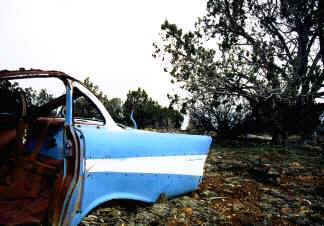
The trash filled swimming pool came to life once again in my imagination and I could almost hear the laughter of children as they splashed "cannon balls" at each other on a hot summer day. Off in the distance I spied a touch of turquoise in the trees; all that was left of the rear fender of a vintage Chevy. This really was a beautiful spot for a resort, but the coming of the Interstate miles away brought all that to an end. Hyde Park was one Route 66 business that just couldn't hang on. | |
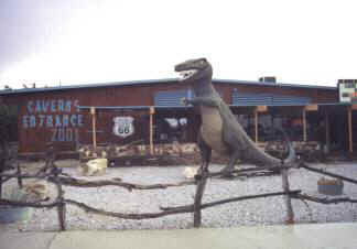
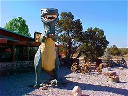
Grand Canyon Caverns 2001 |
|
|
About two miles down the road from the resort ruins of Hyde Park is the turn off to Grand Canyon Caverns, a tourist stop in the best traditions of old Route 66. I turned off the highway and traveled another mile or so to the parking lot of the caverns. I was the only car in the parking lot that March day. Grand Canyon Caverns 2001 was proudly proclaimed on the building and at the entrance a large T-Rex dinosaur stood guard. This is the restaurant and gift shop of the caverns too, and it really is a nice, spacious and clean establishment. I pretty much had the place to myself so it was easy to meet the owner, Charles (Chuck) Carson, and for a few minutes to pass the time of day. If you ever pass this way be sure to stop and enjoy the sights. It will take you back to the days when Mom and Pop tourist attractions lined the old road. As I was walking back to my car I saw another vehicle pull into the parking lot. It appeared that business was about to pick up. ~ March 2001 |
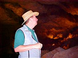
Return to Grand Canyon Caverns ~ 2003 |
||||
| Walter Peck never dreamed that in his haste to get to a poker game with friends he would literally stumble onto a gold mine - or so he thought. It was 1927 and Walter, a woodcutter for the Santa Fe Railroad, was late for his game so he took a short cut through the woods. When he tripped and fell he found himself staring into sinkhole that looked like a bottomless pit. Walter thought he could make out the dull white gleam of bones far below and knew he had narrowly missed adding his own to the collection. | ||||
 |
The future Grand Canyon Caverns had been discovered. Though Walter originally thought he had found a lost gold mine, further investigation proved that it was a natural limestone cave that contained no gold or precious gems at all. Walter wasn't about to give up though. The new U.S. Highway 66 passed close by and with a little promotion he thought he could entice visitors to pay a quarter to see his cave. After he lowered them down into his hole he also thought he could entice visitors to pay 50 cents to be hauled back out too. Walter was a true entrepreneur it seems. | |||
| Today things have changed quite a bit. No longer are visitors lowered down into the caverns on ropes but in modern elevators. Instead of kerosene lanterns, electric lights illuminate the natural wonders of Grand Cavern Caverns. There is a modern motel; restaurant and gift shop for the enjoyment of the new Route 66 traveler. |
|
|||
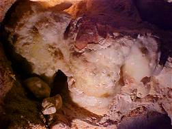 |
There's much to see underground in the caverns: a mummified 150 year old bobcat, civil defense supplies left in the cave from the days of the Cuban Missile crisis, and a recreation of an 18,000 year old Ground Sloth, Gertie, whose bones were found in the cave. This is a real Route 66 Attraction that has been in operation since 1927. It is indeed a must see resort destination. ~ May 2003 | |||
Peach Springs Capital of the Hualpai Nation |
|
 |
Shortly after leaving Grand Canyon Caverns you enter the Hualpai Indian Reservation. About 12 miles down the road there's a steep downgrade that leads to the Route 66 town of Peach Springs. Peach Springs got its name from the peach trees found growing by the spring here. Because the steam locomotives used water from the spring a water tank and station were built by the railroad here. A town grew up around the station and by 1883 it was said to have ten saloons but no schools or churches. |
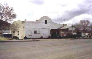
| Today Peach Springs is the administrative headquarters of the Hualpai Indian Nation. In the hey day of Route 66 there were many motor courts, cafes and assorted tourist related businesses operating out of Peach Springs. When the Interstate bypassed Peach Springs, the town still held on. Not much is left of the Route 66 businesses in Peach Springs today though except for a few abandoned stone buildings and a classic old garage that is still in operation; a survivor of the old road. | 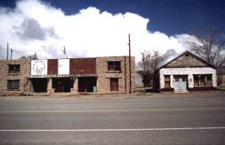 |
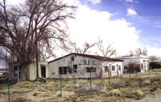
Truxton, Arizona |
|
| A few more miles down the road from Peach Springs is the old town of Truxton. The community of Truxton originally developed around a gas station and cafe along Route 66 in 1951. The name of the town comes from the famous Beale Camel Expedition. Lieutenant "Ned" Beale stopped at the spring here in 1857 and named it Truxton in honor of either his brother Truxton or his mother, Emily Truxton Beale. Once bypassed by the Interstate, Truxton became a mere shell of the town it once was. This old Truxton cafe was closed, and judging by the growth of weeds in front it hasn’t served the traveler in quite awhile. |
|
|
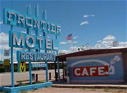
The Frontier Motel and Restaurant in Truxton has seen a lot of action over the years. Until recently the old neon sign and artwork was in need of repair. Using matching funds from the Route 66 Corridor Preservation Act administered by the National Park Service it has been repaired and painted and is a fine example of vintage Route 66 road art. To me there's something friendly and comfortable in signs like these. |
Photographs taken March, May 2001 & May 2003
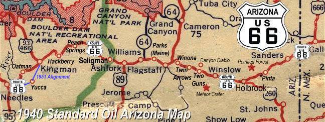
Click on an area or city of Route 66 on the map below to take a cyber tour of that section of the Mother Road |
|
|
NAVIGATION NOTE: Buckle up and hold on to your mouse! These pages are arranged like the map above. I have set up this site as if you were traveling from EAST to WEST, much like the Joad family in The Grapes of Wrath. You can click on the Route 66 shields to "travel" the Mother Road in either direction though. Clicking West Route 66 or East Route 66 will take you to the next town or area on the map in that direction. Or you can select any shield below to take you to that specific state. |
|
To Valentine & Hackberry |
To Seligman |

© Copyright 2003 GRandall Web Design Service