 |
Bones of a Country ~
|
|
[HOME] [WESTERN AMERICANA GALLERY] [ROUTE 66 HOME] [ROUTE 66 WEST] [ROUTE 66 EAST]
|
Bones of a Country ~
|
|
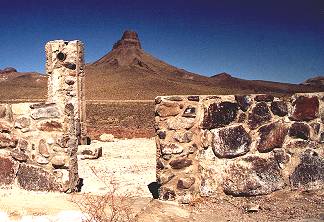
Cool Springs Camp - Silent Sentinel in 2001 |
|
| The ruins of an old gas station at Cool Springs Camp on the right of the road stand as a silent guardian at the entrance to the canyon beyond. A short distance past these ruins are the remains of Ed's Camp. Then Route 66 becomes narrow and steep on the Goldroad grade but presents no problem to the careful driver, and when the speed limit drops - take it seriously. Of all the stretches of Route 66 this was perhaps the most intimidating of all, with its steep grades, narrow road, and hairpin curves. In the Grapes of Wrath, what was it Pa Joad said about this old road as he looked back at it from the safety of the Colorado River? Didn't he compare those mountains to the bones of a country? This was the Mother Road of the Grapes of Wrath, and the bones of a country opened before me as I started into the canyon on my way to Oatman. | |
|
|
Cool Springs Camp - A Rebirth in 2003 |
||||
 |
In May 2003 during the Arizona Fun Run I had a surprise in store for me as I wound my way up to Oatman. Passing what once had been the ruins of Cool Springs I found a rebirth going on! |
|
||
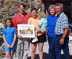 |
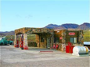
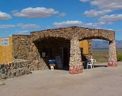
Ned and Michelle Leuchtner have a dream! Last year they bought the ruins of the old Cool Springs Camp and plan on restoring it to its former glory. Originally built in 1926, this Mobil Oil Station serviced Route 66 travelers until it burned in 1966. During the hey day of Route 66 it had a cafe and tourist cabins and was the last stop before the much feared Gold Road and Sitgreaves Pass. Ned, a real estate agent, and his wife, Michelle, are from Chicago and plan to eventually relocate to the land of little moisture, fresh air and abundant sun of the Arizona desert on Route 66. The resurrection of Cool springs Camp will be a boon to the Mother Road. Thanks to preservationists like the Leuchtner's the experience of old Route 66 will live on for future generations to enjoy. | |||
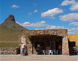
Cool Spring is Open for Business 2004 |
||||
Great news for Route 66 fans. After decades of neglect Cool Springs Camp has been restored and is now open for business. This is a must stop for the Route 66 traveler. Cool Springs features a gift shop and art gallery highlighting unique road memorabilia specific to Cool Springs and the immediate vicinity.Thanks to the Leuchtner family and friends Cool Springs lives again as a part of our precious Route 66 heritage! |
|
|||
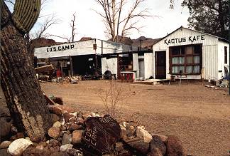
Ed's Camp |
|
|
Ed's camp is a rather interesting collection of time worn buildings and assorted structures left to bake in the desert sun. The architecture is what I would call desert rat rustic. It looks like the building materials used here were for the most part "found" or salvaged from other structures. Ed's Camp is definitely a relic left over from the days when this narrow road to Oatman was US Highway 66. Jack Rittenhouse even mentions Ed's Camp in his 1946 "Guide Book to Highway 66" as having a gas station for the early traveler. Ed originally came to the area as a miner in 1917 and it didn't take him long to realize that the real gold could be found servicing the Route 66 traveler. He established his camp around 1919 and business was so good he never got around building a proper building, he just threw up a roof to provide some measure of protection from the hot desert sun and Ed's Camp was born. Today the camp is deserted, but the odd buildings survive to temp the artistic talents of modern photographers. |
Shaffer Fish Bowl Springs |
|
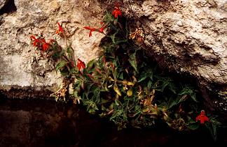
| Route 66 continues up the old Gold Hill Grade into the Black Mountains. A few hairpin curves later is the site of Shaffer's Fish Bowl Springs. This is an easy place to miss, in fact, the first time I made this trip I did just that. The spring is not marked, but if you see stone steps seemingly cut into the cliff on the left as you head towards the summit of Sitgreaves Pass - you're there. There is a small clearing along the road here where you can park. I spent a few minutes taking pictures and going up the stone steps to the "fish bowl". The delicate Monkey Paw Orchid seemingly growing out of solid rock right at the spring particularly impressed me. Such a pretty, water-loving flower is the last thing you would expect to find in this harsh desert country. |
|
GoldRoad and Sitgreaves Pass |
|
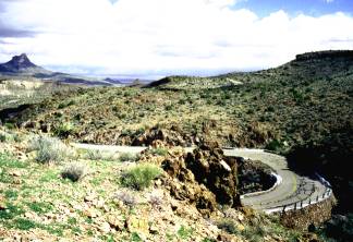
| This part of Route 66 was bypassed by a new straighter alignment in 1953 that did away with the need to traverse the steep mountain grades to Sitgreaves Pass. I remember going around a curve and looking to my right at the road going in the opposite direction. I could have rolled down my window and spit on it! I've done a lot of traveling in the western mountains and these are some of the sharpest hairpins I could recall being on. I could understand now why some travelers of old Route 66 would pay the locals to drive their car up the grade for them or even have their vehicle towed over the summit. |
|
|
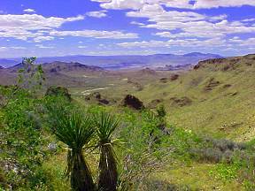
The summit of Sitgreaves Pass, at an elevation of 3556 ft, affords quite a view of the surrounding country. Right at the top of the pass there is a pull off that you can stop at to really enjoy the view. If you look closely you will see the foundations of a building - all that is left of an old gas station and ice cream parlor that once serviced the weary traveler on this portion of Route 66. If you look down the canyon back the way you just came you might be able to make out a faint trail hugging the left hillside. That faint trace is all that is left of the Old Beale Wagon Road. Imagine the history that passed this way! |
Goldroad, Arizona Route 66 Ghost Town |
|
| The western grade is just as steep and narrow with more dandy hairpin curves to navigate as it winds down the mountain. Unbelievably, tucked in among the gulches of the steep hillside are the remains of the town of Goldroad. Goldroad does have an operating gold mine though, and for a nominal fee you can tour it or take a stagecoach ride around the area. The ruins of the old town impressed me. The old walls and foundations were built of native stone, and as such blend in with the surrounding rocky country. The ruins only become really apparent upon close scrutiny of the gulches. Boy, it was a wild and woolly life back then. The old road winds down the mountain for a couple more miles before the old mining town of Oatman comes into view. In Oatman, stand by for one of the most unique experiences to be found anywhere along Route 66! | 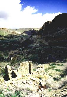 |
Photographs taken March 2001, February 2002 & May 2003
Click on an area or city of Route 66 on the map below to take a cyber tour of that section of the Mother Road |
|
|
NAVIGATION NOTE: Buckle up and hold on to your mouse! These pages are arranged like the map above. I have set up this site as if you were traveling from EAST to WEST, much like the Joad family in The Grapes of Wrath. You can click on the Route 66 shields to "travel" the Mother Road in either direction though. Clicking West Route 66 or East Route 66 will take you to the next town or area on the map in that direction. Or you can select any shield below to take you to that specific state. |
|
To Oatman |
To Kingman |

© Copyright 2003 GRandall Web Design Service