|
Route 66 and
|
|
[HOME] [WESTERN AMERICANA GALLERY] [ROUTE 66 HOME] [ROUTE 66 EAST]
|
Route 66 and
|
|
Golden Shores of California - West End of Route 66Foothill Boulevard leaves Rancho Cucamonga and travels through the Route 66 cities of Upland, Claremont, La Verne, San Dimas, Glendora, Azusa, Duarte, Monrovia, Arcadia, and Pasadena. Here and there traces of the old Mother Road can still be seen tucked away between more modern strip malls and chain restaurants. In Azusa look for the sign for the old Foothill Drive-In, it speaks of another time when beautiful summer nights beckoned families and lovesick teenagers out for a night of entertainment. Another relic from the past is the Trails Restaurant in Duarte, a famous stopping off place on Route 66. Both the Azusa Drive In and Trails Restaurant are closed now, having succumbed to modern progress, but have an ally in the California Route 66 Preservation Foundation which is trying to save the signs for future generations to enjoy. |
|
Monrovia,
California
Monrovia offers the Route 66 fan some delightful visions from yesteryear. One block north of Colorado Blvd on Shamrock can be seen a vintage gas station left over from an earlier alignment of Route 66. Follow Shamrock north to West Foothill Blvd and turn left. Along this early alignment of Route 66 can be seen architecture from the 1920s and 1930s plus older motor courts such as Harding Court. Soak up the atmosphere of the place then move down the road to the one of a kind Aztec Motel on the corner of W. Foothill and Magnolia. The Aztec is still open, and with the resurgence of interest in the Mother Road hopefully it will continue to be so. The Aztec Motel is as unique a structure to be found anywhere on Route 66, and is a classic of the old highway in California. |
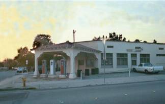
This classic gas station in Monrovia stands silent and forgotten now. Once this station was a hub of activity along an early alignment of Route 66. |
|
 |
Pasadena,
California
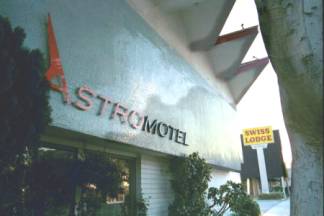
Foothill Blvd. becomes Colorado Blvd. as it moves west into Pasadena. Route 66 Motels and cafes can be seen here and there, quaint anachronisms in the hustle and bustle of modern Pasadena. One such motel is the Astro Motel and looks like it could have come straight out of the Jetson’s cartoon series! This motel must have once attracted the vacationing family with its "futuristic" design back in the late 1950s and early 1960s. |
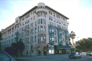
| The Pasadena historic district has many old buildings still evident from the early Route 66 days. Classic art deco intermingles with 1900s architecture to form a colorful eclectic collection of vintage buildings that hint of the Golden Era of Southern California. An old Pasadena hotel still shows its former glory along Route 66. |
|
|
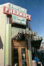
The Fair Oaks Pharmacy has seen a lot of Route 66 pass by its doors. The Pharmacy originally opened in 1915. Eleven years later it was there for the birth of Route 66 and was on the legendary highway’s first alignment from 1926 through 1934. Today it has been restored as a fully operational soda fountain. Grab an ice cream float and linger awhile in the atmosphere of the place. |
| The
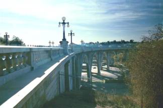
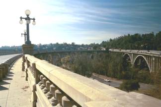
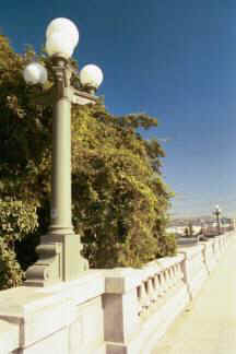
Colorado Street Bridge
Another relic of the Mother Road that actually predates Route 66. This gracefully arched bridge was originally built in 1913 to span the Arroyo Seco from Pasadena into Eagle Rock. It was 13 years old when it became a part of Route 66 and continued to be a part of the Mother Road from 1926 through 1940 when the Arroyo Seco Parkway opened. |
|
|
|
| My
Route 66 Guide in Los Angeles
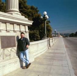
Scott Piotrowski, author of the great Route 66 guide, "Finding the End of the Mother Road: Route 66 in Los Angeles County" at the Buena Vista Street Bridge over the LA River. This early alignment of Route 66 passes Elysian Park and once brought the traveler into downtown LA. Scott is one of the leading experts on the old alignments of Route 66 in the LA area, in fact he is writing a book on the subject that should be published in June 2002. He was my guide for this portion of my Route 66 explorations and all I can say is that I’m sure glad he was driving! |
 |
|
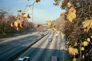
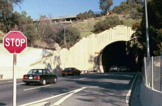
The Arroyo Seco ParkwayThe Arroyo Seco Parkway opened in December 30, 1940 and became the new alignment of Route 66 from Pasadena to Los Angeles and one of our nation’s earliest freeways to boot. Even today the classic lines and attention to detail can still be seen in the construction of the parkway and it’s beautiful tunnels. You will leave the Arroyo Seco Parkway at the Sunset Blvd. exit to continue on Route 66. |
|
|
7th & Broadway End of Route 66 in Los Angeles |
||||
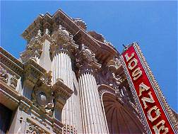 |
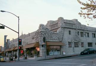
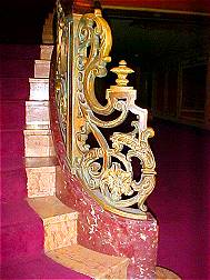
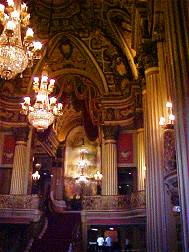
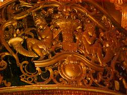
7th and Broadway in the heart of the "City of Angels" was once the western terminus of Route 66 in the days before it went to Santa Monica. Downtown Los Angeles is a busting place and 7th and Broadway is perhaps the busiest area of all. This area is home to some of the most splendid examples of 1920 – 1930s architecture to be found on Route 66. The movie palaces, cafes, and businesses speak of another time in America when buildings were not only functional but also works of art. There are some beautiful buildings from a time when Hollywood ruled and the theaters themselves were more exciting and elegant than the movies being shown. The Los Angeles Theater is a wonderful case in point. | |||
 |
|
|
||
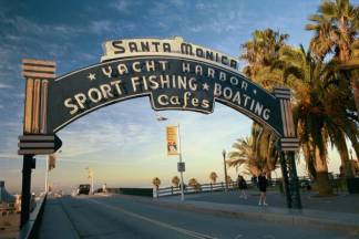
Santa Monica - Western End of Route 66 |
||
From Figueroa St. to Sunset Blvd. then on to Santa Monica Blvd. you will be following the last alignment of Route 66 to the Pacific Ocean. Santa Monica Blvd. travels through Hollywood, West Hollywood, Beverly Hills and finally Route 66 ends in Santa Monica at Palisades Park and the famous Santa Monica Pier on the Pacific. |
||
|
||
|
|
|
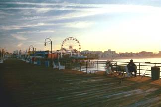
| Santa Monica Pier at Sunrise
This was a special trip for me. I was going back in time as I walked down the boardwalk of the pier at sunrise. The last time I was here was when I was a young boy in 1967. The amusement park was not built back in those days. But I sure do remember fishing off this pier more than once with my family and friends. It was nice to see that the old pier had stood the test of time and appeared to be doing quite well. I stood at the rail and watched the sun come up over the Santa Monica hills and remembered things. Silently the ghosts from my past came to visit with their memories of a bygone time when the world was young because I was young. It was a bittersweet time, but a pleasant time non-the-less. |
||
Photos taken December 2001 & April 2003
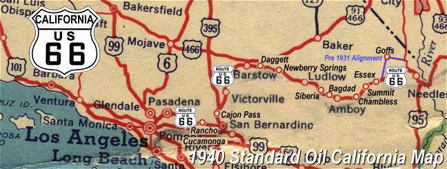
Click on an area or city of Route 66 on the map below to take a cyber tour of that section of the Mother Road |
|
|
NAVIGATION NOTE: Buckle up and hold on to your mouse! These pages are arranged like the map above, Pacific Ocean being West Route 66 and the Colorado River East Route 66. I have set up this site as if you were traveling from EAST to WEST, much like the Joad family in The Grapes of Wrath. You can click on the Route 66 shields to "travel" the Mother Road in either direction though. Clicking West Route 66 or East Route 66 will take you to the next town or area on the map in that direction. Or you can select any shield below to take you to that specific state. |
|
You are already here at the west end of Route 66 |
To Rancho Cucamonga and San Bernardino on Foothill Blvd. |

© Copyright 2003 GRandall Web Design Service