|
New Mexico
|
|
|
New Mexico
|
|
Go to Route 66 State: |
|
| Route 66 in New Mexico is a special place. New Mexico is indeed the Land of Enchantment. For many people traveling the old Mother Road during its hey-day New Mexico presented the first glimpse of the exotic cultures of the southwest. For the Route 66 traveler coming from back east it was as if they had entered another country. The fascinating Native American and Spanish cultures encountered along New Mexico's Route 66 opened up new worlds never dreamed of before by these people. New Mexico presented the adventure of discovery - from the old Indian Pueblos dating back to days before European colonization to the old town plazas of Santa Fe and Albuquerque; bustling with the activity of commerce before there was even a United States of America. Rich heritage steeped in history blended with the ribbon of highway known as Route 66. |
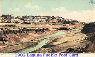
| Native Americans have lived here for over 10,000 years. Starting with the earliest paleo-hunters in search of Mastodon and ancient Bison to the earliest farmers around the time of Christ, these native peoples have left their mark on the land. When the Spanish first arrived in the 1500s they found the descendants of these earliest people already living in multistoried adobe pueblos along the Rio Grande in western New Mexico and parts of eastern Arizona just as they do today. Perhaps the first explorer who would leave his mark on the land that would someday become Route 66 was Francisco Vázquez de Coronado. He blazed a path as far east as Kansas and west as Arizona in search of the fabulous treasure cities of Cíbola, forging a trail that would someday become modern-day Route 66. |
|
|
|
|
| Perhaps Route 66 best exemplifies our American Dream in its businesses and New Mexico has plenty of those left. The post war years brought unparalleled prosperity as "Mom and Pop" businesses sprang up to service the Route 66 traveler and vacationer. America was on the move. New businesses sprung up, and older ones thrived. Route 66 has always been an economic resource for the towns she passes through. With not much more than an idea and a determination to work hard a person could build a profitable business along the old highway. Many a successful roadside business was started on a shoestring budget and a dream. With imagination a whole new world was created. Crates left over from the war became walls of an old motor court. Oilcans became shingles used to roof an old service station. Cast away bottles and roadside trash became the material to create a wondrous roadside attraction. Diners could be ordered from a catalog and shipped by railroad to their destination. | ||||
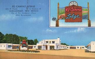 |
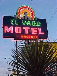
One of the most interesting phenomena of highway business evolution is perhaps what happened to the old motor courts, they began to evolve into the modern motel. Motels were the next generation of lodging for the traveler, emerging dominant after the war. The individual cabin motif so popular during the early years of Route 66 was abandoned in exchange for attached room facilities, laid out in an L or U shape. Each still was unique in character. Each still enticed the weary traveler to stop and rest awhile. Swimming pools, free TVs, and air conditioning tempted the most seasoned highway adventurer. These were the modern motels in a day before the motel chains. The brightly-lit neon lights proclaimed the "Motel Rows" of a hundred towns along Route 66. The real glass drinking glasses carefully sealed in waxed paper, individually wrapped bars of soap, and toilets sanitized for your protection greeted the tourist along Route 66 and the other two-lane highways. | |||
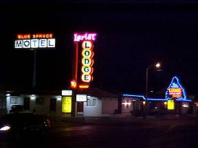
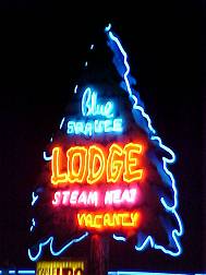
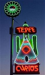
| The presence of so many travelers, most of who had money to spend, resulted in unprecedented competition along the highway. Lights were used to a far greater degree than today. Neon signs were widespread during this period, as were buildings painted with bright colors and designs that attracted the eye. Anything to get travelers to stop was used. Luminous neon designs flashed, colorful cabins beckoned, and unique architecture would catch the eye of the passer by. Signs such as "Tucumcari Tonight!" were placed along the highway, beckoning the motorist to stop. Tourist and curio shops also sprung up all along the route creating a carnival like atmosphere along "America's Main Street." |
|
|||
| New Mexico hosts many miles of unbroken stretches of Route 66 that can be driven even today and give the road wanderer a real glimpse into what it was like along Route 66 during its hey-day. Today New Mexico has some of the best examples of highway kitsch left along the old Mother Road. Towns like Gallup, Albuquerque and Tucumcari proudly preserve their vintage neon signs with the help of the Route 66 Corridor Act monies and the support of the New Mexico Route 66 Association. Vintage trading posts and authentic roadside cafes and diners still entice the traveler to stop. New Mexico is truly the "Land of Enchantment." | ||||
|
|
|
| Jack D. Rittenhouse in his 1946 "A Guide Book to Highway 66" describes New Mexico thus: |
|
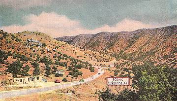
| "For the most part, US 66 through New Mexico is not as wide or well-paved as in Texas. Until recently, it has been deeply pitted in many places, but the state is conducting an extensive program of highway improvement and is giving special attention to US 66. Since the region is often very arid, it is wise to carry a spare container of water now for your car, and drinking water would come in handy, too. Don't turn off any side roads without inquiring locally as to road conditions." |
But Cyber 66 in New Mexico is always dry,
and the road conditions are great
|
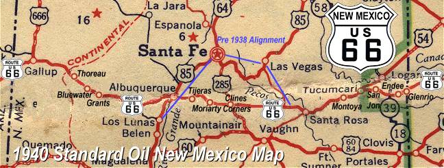
Detailed Vintage New Mexico Road Maps: [1928 Eastern N.M.] [1928 Central N.M.](Route 66 goes through Santa Fe) [1926 Western N.M.] |
[1936 Eastern N.M.] [1936 Central N.M.](Route 66 bypasses Santa Fe) [1936 Western N.M.] |
Click on an area or city of Route 66 on the map below to take a cyber tour of that section of the Mother Road |
|
|
NAVIGATION NOTE: Buckle up and hold on to your mouse! These pages are arranged like the map above, from the western state border to the eastern state border. I have set up this site as if you were traveling from EAST to WEST, much like the Joad family in The Grapes of Wrath. You can click on the Route 66 shields to "travel" the Mother Road in either direction though. Or you can select any shield below to take you to that specific state. |
|
To Gallup, New Mexico |
To Glen Rio, New Mexico |

© Copyright 2003 GRandall Web Design Service