 |
Amboy Area & the Mojave Desert |
|
[HOME] [WESTERN AMERICANA GALLERY] [ROUTE 66 HOME] [ROUTE 66 WEST] [ROUTE 66 EAST]
|
Amboy Area & the Mojave Desert |
|
Chambless, California and the Road Runner's Retreat |
|
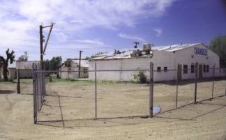 |
The town of Chambless is only about three miles from Summit. Jack Rittenhouse in his 1946 guidebook mentions a wide porched gas station with cafe and several tourist cabins as being located here. He remarked that it was one of the few shady spots on the entire desert route. The gas station and market is still standing, but was closed now, and the wide porch is just a memory today. Evidently it blew down a few years ago in a violent Mojave windstorm. Too bad, I bet it provided a welcome relief for travelers. |
| To be able to get out of the searing sun for just a little while must have made the old market quite a gathering place for the road weary. The market itself was built of hand made blocks of adobe brick; a very sensible building material in the desert. Adobe naturally provides some protection from the elements. It is cool in the summer and warm in the winter. | |
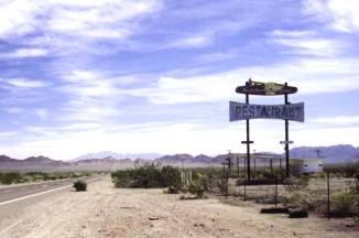 |
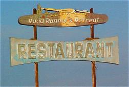
My guidebook mentions the abandoned Roadrunner Cafe and Gas Station being about a mile and a half west of Chambless and I definitely wanted to check it out. I was wondering if I had seen a picture of the place before in a piece of original artwork from a noted Route 66 artist. It was a piece of artwork that I had downloaded from the Internet and was using as a desktop for my computer; one that I particularly liked I might add. |
I was not disappointed when I drove up to the Roadrunner Cafe. There before me was the scene I had seen many times on my computer's desktop. So this was where Route 66 artist Jerry McClanahan had found the subject for his great painting. For those of you that have not visited Jerry's web site, I would recommend it wholeheartedly. Make sure that you check out his Roadrunner's Retreat painting, you won't be sorry. This was purely great. I knew that everytime I looked at Jerry's painting on my computer from now on it would conjure up pleasant memories of my trip. |
|
You can find a link to Jerry's web site in my links section of my Route 66 home page. |
|
|
|
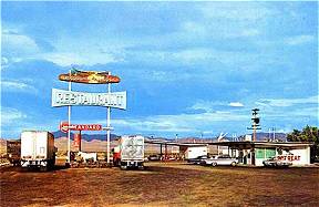 Postcard from the 1950s |
 The Faded Sign Reflects the Afternoon Sunlight ~ 2003 |
Amboy's Quiet Now... But Once... |
|
|
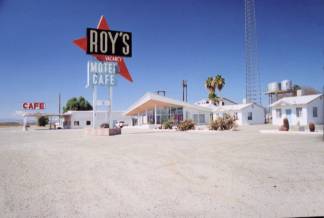
Ten miles down the road I knew I would be coming to Amboy and Roy's Cafe. I had read about Roy's Cafe, Gas Station and Motel in Michael Wallis' book, Route 66 the Mother Road and was really looking forward to seeing it. I knew that Buster Burris, the original owner had since passed away but I wanted to capture on film the legacy he left for us Mother Road enthusiasts. Buster originally opened his Garage, Cafe and Motel in 1938. It had become a landmark along this portion of Route 66, and many a traveler who broke down in the Mojave was glad he was there. |
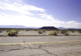
| Amboy Crater rises above the desert floor just outside of town. It was an old Route 66 tourist attraction once. Today the Amboy Crater stands silent and lonely. But it wasn't always like that. Once, about 60 years ago along this stretch of Route 66 it woke up. | |
| On that fateful day the residents of Amboy awoke to see a billowing black tendril of smoke rising from the center of the crater, high into the sky. It seemed that what everyone had thought was a dormant volcanic cinder cone was now coming to life with a promise of an eruption that would rival Mt. Vesuvius. With an eruption eminent, the residents prepared to flee. Route 66 and the Santa Fe mainline where shut down as people braced themselves for the disaster. |
|
| Funny thing though, there was none of the distinctive rumblings of the earth usually associated with volcanic activity such as this. Furthermore, the smoke didn't seem to get any thicker either. A team of investigators was dispatched to fly over the crater to try to determine the extent of the impending calamity. What they found surprised them. Instead of billowing clouds of ash, red-hot lava and steam, they saw a small, localized fire in the center of the crater and what looked suspiciously like burning tires and trash. The hoax was uncovered! An investigation was promptly set up to find the perpetrators of this dastardly scheme. The clues led all the way to Barstow and ended with some kids from the local high school. Evidently these local youth had concocted a clever plan to simulate a natural disaster, and hauled old tires and junk to the crater then set the pile on fire. The officials duly chastised the local kids. All in all, I can't help but think that the officials found a little humor in the stunt, but not in front of the kids of course. Such a grand plan, the disciplinary officials might have thought. Why hadn't they thought of something like that before? Downright creative it was too! | |
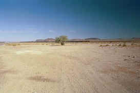
Bagdad, California has had Better Days |
||
|
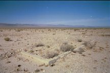
Bagdad is located about six miles west of Amboy down Route 66. I knew that all traces of the town were gone now. What was left of the old Route 66 town had been destroyed in 1991 when the site had been used as a storage area for gas pipeline. The old townsite was supposed to be marked by two trees, one tree along the highway and the other, a palm tree, along side the railroad tracks. Those trees were all that marked the site of Bagdad now. I saw a small tree growing along the road in the distance. This had to be Bagdad; the mileage was right, the tree was right. When I stopped I couldn't see any palm tree along the railroad tracks, but I did notice a small sign there. This was the type of sign the railroad placed to identify towns and sidings along its route. | |
| I had a feeling I'd find the answer to my questions about Bagdad on that sign. As I approached the sign the letters spelling out Bagdad became apparent. So this was the old town site, this wide spot in the road was all that was left of the once thriving Route 66 town. I still didn't notice the palm tree though. I glanced around me, out over the expansive desert, out at the old highway that cut a path through the scrub and rocks of the Mojave, and at this small clearing by the tracks. Bagdad was certainly gone now. The only evidence that it ever existed was lettered on that lone railroad sign. | ||
|
As I was framing the old railroad sign for the picture I noticed a single telephone pole by the tracks in my viewfinder. One telephone pole all by itself, which was kind of strange I thought. It was a funny looking pole too. Suddenly it dawned on me that I was looking at the palm tree, or what was left of it. The palm fronds were gone, blown, baked or burned off, I couldn't tell. All that was left was a brown crusty trunk near the tracks. Sad, it too had seemed to give up and go the way of the town it once watched over. |
|
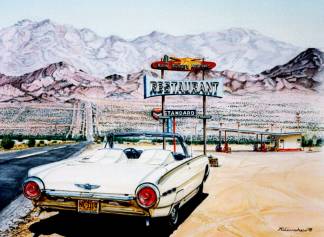
| Bagdad was a real town once. It was already almost half a century old when Route 66 first came through here in the late 1920's. Bagdad was founded in 1883 as a shipping point for the mines and ranches of the area. Once it was a thriving community of over 600 hardy souls, complete with hotels, churches, and even a school. There was a railroad depot and Harvey House located here also. During the hey day of Route 66 the town provided all the amenities the traveler could want. And the real Bagdad Cafe once was the social center of the desert in this area. | 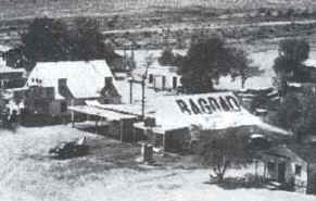 |
|
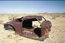 Old rusty car at Bagdad. I wonder if it is the same one that's in the picture of the old Bagdad Cafe. |
|
From the 1940's through the 1950's the Bagdad Cafe was the place to gather on a Saturday night. With its juke box and dance floor the cafe became the entertainment capital of the Mojave Desert between Needles and Barstow. The music died in 1968 when the cafe closed. In 1972 when the Interstate opened miles to the north of Bagdad the town started its rapid decline. And sadly, what was left of Bagdad was scraped off the face of the earth in 1991 when the gas pipeline storage area was built. Now even that is gone. |
Photographs taken March, May 2001 & April 2003
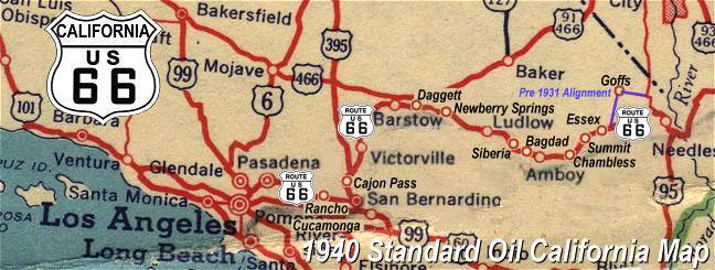
Click on an area or city of Route 66 on the map below to take a cyber tour of that section of the Mother Road |
|
|
NAVIGATION NOTE: Buckle up and hold on to your mouse! These pages are arranged like the map above, Pacific Ocean being West Route 66 and the Colorado River East Route 66. I have set up this site as if you were traveling from EAST to WEST, much like the Joad family in The Grapes of Wrath. You can click on the Route 66 shields to "travel" the Mother Road in either direction though. Clicking West Route 66 or East Route 66 will take you to the next town or area on the map in that direction. Or you can select any shield below to take you to that specific state. |
|
To Siberia and Ludlow |
To Mojave Outposts |

© Copyright 2003 GRandall Web Design Service
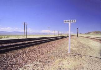
 Compare this picture of
the Bagdad townsite in 2001 with that of the Bagdad Cafe and townsite in the 1950's below
right.
Compare this picture of
the Bagdad townsite in 2001 with that of the Bagdad Cafe and townsite in the 1950's below
right.