 |
Sunbaked Route 66
|
|
[HOME] [WESTERN AMERICANA GALLERY] [ROUTE 66 HOME] [ROUTE 66 WEST] [ROUTE 66 EAST]
|
Sunbaked Route 66
|
|
Free Water at Essex, California |
|
|
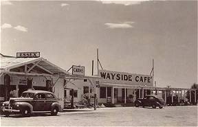
Another ten miles down the road from Goffs on the old pre-1931 alignment of Route 66 the old road rejoins the National Old Trails Highway at Essex. Jack Rittenhouse described Essex as a small Mojave Desert community that chiefly served the needs of the tourists. Essex once provided towing services, gas stations, markets and cafes to the Route 66 traveler. This post card from the 1940s shows Essex in the hey-day of Route 66. |
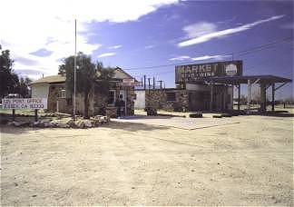
| Today Essex is but a shadow of its former self. The Essex post office and abandoned market next store were very interesting. Built out of native stone they offer some nice photo opportunities. I could feel the presence of the old road here. The old abandoned stone market, lonely and neglected now, stands as a monument to the Mother Road. It hints at a time when cars lined up here to buy ice cream, cold drinks and the other assorted supplies that travelers always seemed to need once on the open road. |
|
|
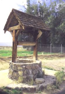
It also had a free drinking fountain in the desert. About a
hundred feet from the old market I found the water well off by the side of the road. It
was a cute little stone well that had a shake shingle roof and looked a lot like a classic
old wishing well. The water had long been turned off, and the plumbing stripped of its
fixtures, but it still stood in silent testimony to the days when it was a very popular
stopping place on Route 66. In those days gas stations charged 10 cents for a glass of
drinking water or 10 cents for a gallon of radiator water. Thanks to the Automobile Club of Southern California who put the drinking fountain in, that wasn't an issue anymore for the Route 66 traveler. I imagine that this little well was a very popular place on those hot summer days so long ago. |
| Across the highway from the well I saw a Route 66 Shield on a mileage sign and went over to investigate. It didn't quite look right to me. As I got closer I saw why. It was made of plywood. It wasn't an official highway sign, but one that was obviously placed by a fan of old Route 66. I was glad it was there, it looked good on that mileage sign beside the road. It belonged there. Weathered though it was, its very presence gave me a comfortable feeling. | 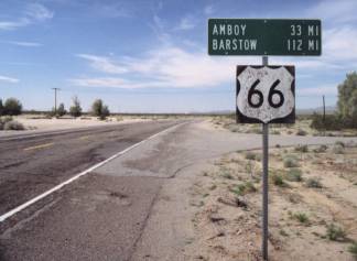 |
|
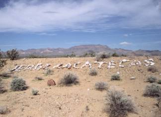
There is an earth berm on the right side of the road going west that runs parallel to old Route 66 between Essex and Amboy. This berm has provided the "canvas" for travelers wishing to leave a statement of their passing for the entire world to see. As I traveled along the highway I could see words formed out of rocks, bottles and tin cans; messages left by previous desert wanderers through the area. No telling how long some of these messages and names have been weathering in the desert here. Some were unreadable, as time and the elements sought to erase all traces of these long ago travelers. Then again some were quite legible and looked as if they had been placed there only the day before. |
Desert Art at Danby, California |
|
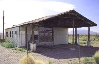 |
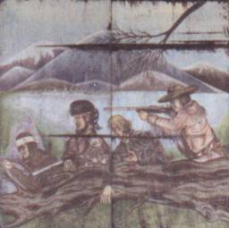
About ten miles from Essex another old Route 66 community can be found along the road. The town of Danby, a ghost of its former self, lay bare and blasted by the unforgiving Mojave sun. Many of these towns along this stretch of the road were once water stops for the railroad, a throw back to the steam era of railroading. When Route 66 came along they became more than railroad stops and provided vital services for the desert traveler. Danby was no different. The gas stations and cafes are closed now, but here and there are remnants of the past highway glory. |
| At Danby I found an abandoned wood frame and tin siding structure that looked to have been a garage at one time. What made this old building interesting was a mural painted on the front of the building showing a scene from western lore. It consisted of cool mountains; a flowing river and what looked to be mountain men engaged in some small-unnamed skirmish with the local population. The snow-covered mountains depicted in the mural were reminiscent of Rocky Mountain high country scenes rather than the open expanses of the Mojave Desert. Maybe it was an attempt by the owner to say, don't worry, the summer heat may be bad here, but there are cooler places out there somewhere. Take heart, if you follow the road long enough you just might find them. Then again I may be letting my imagination get to me, that small skirmish could really be saying if you don't pay your bill, this is what we will do to you. |
|
Cadiz Summit and a Walk Back Through Time |
|
|
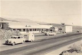
A few more miles down the road and I came to Summit. Jack Rittenhouse describes this place as a desert oasis comprised of a gas station, cafe and some tourist cabins. This postcard from the 1940s shows Summit as a small but popular desert outpost. I imagine this is pretty much what it looked like in Jack Rittenhouse's time. |
|
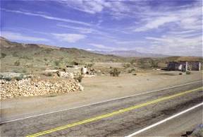
Today there is nothing left but foundations to tell that once this was a Route 66 stop. It probably was an important stop too. Though there is not a noticeable grade as one travels westbound Route 66 to get to Summit, there is on the eastbound highway. Motorists traveling east on the old highway would have just climbed a deceptively steep grade coming from Chambless to get to Summit. During the summer months this would have meant it was time to stop and let the car cool down. What a great place for a gas station and cafe! |
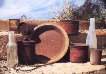
| Across the road a glint and sparkle of light caught my attention. There was a lot of broken glass out there. And then I saw the brown black shapes of cans piled all along the small gullies of the desert across the road. An old Route 66 trash dump! The piles of rusting cans stretched out for a great distance into the desert landscape. The old trash dump was more expansive than I had first thought. It encompassed years of Route 66 discards from the small outpost at Summit. The nature of Summit's Route 66 business was in evidence everywhere. I found piles of oil cans, bits and pieces of automobile parts, more tin cans: fruit cans, coffee cans, beer cans and the like. |
|
| I allowed myself to be drawn into the magic of the place; each little discard seemed to bring me closer to the people who had come this way once. A broken stoneware soup bowl lay among the tin cans, its design strangely familiar to me. It tugged at the corners of my mind, gently pulling memories of my childhood out from where I had hidden them. Memories I hadn't thought of for decades. The soup bowl fragment conjured up an image of Formica counters, oscillating fans and fly paper, an image of a nameless road cafe that my family stopped at once another lifetime ago. I was amazed at the memories this old trash from the 1950's, tossed out and lying forgotten in the desert for almost fifty years, could bring out in me. These old piles of garbage were fascinating. | |
Photographs taken January and March 2001
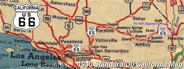
Click on an area or city of Route 66 on the map below to take a cyber tour of that section of the Mother Road |
|
|
NAVIGATION NOTE: Buckle up and hold on to your mouse! These pages are arranged like the map above, Pacific Ocean being West Route 66 and the Colorado River East Route 66. I have set up this site as if you were traveling from EAST to WEST, much like the Joad family in The Grapes of Wrath. You can click on the Route 66 shields to "travel" the Mother Road in either direction though. Clicking West Route 66 or East Route 66 will take you to the next town or area on the map in that direction. Or you can select any shield below to take you to that specific state. |
|
To Amboy and Bagdad |
To Goffs |

© Copyright 2003 GRandall Web Design Service