 |
Mojave Desert Towns |
|
[HOME] [WESTERN AMERICANA GALLERY] [ROUTE 66 HOME] [ROUTE 66 WEST] [ROUTE 66 EAST]
|
Mojave Desert Towns |
|
| The Mojave Desert! The name
conjures up visions of a sun scorched waterless waste land, bleached bones of man
and animal eroding out of the sand dunes and potential death just over the next rocky
rise. Travelers on old Route 66 were wary of this desert crossing, holding up in hot motel
rooms in Needles or Barstow, waiting for the sun to go down before attempting to cross.
Travelers prayed for a safe journey with no breakdowns in the lonely stretches between
towns: to get over the desert before the sun returned to blast the land with 120 degree
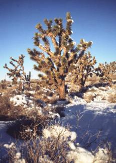
heat. But there can be another side of this desert, one that is not thought of by the traveler. During the winter it can get cold here as this snow covered Joshua tree attests to. I took this picture in January 2001. With the moisture from the snow, spring 2001 promises to be alive with wild flowers. |
 |
Cool, "Alpine" Goffs, California |
|
|
|
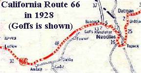
| Route 66 once again rejoins the Interstate at Needles. A few miles down the Interstate the Hwy 95 exit brings you back to Route 66. This portion of the old road was the pre 1931 alignment of Route 66 and led to the little desert community of Goffs, California. | |
| In the early days of Needles, residents thought that Goffs was a nice place to go to beat the Mojave heat. Actually Goffs is a little higher in elevation than Needles, a fact that prompted residents of the Colorado River town to spend their summers here. They thought it was cooler in Goffs. Why melt in the 120-degree heat of Needles when you could enjoy the cool alpine temperature of 115 degrees in Goffs? |
|
|
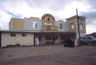
The pre-1931 alignment of Route 66 that I was travelling on was still used regularly after it was bypassed by the newer alignment of Route 66. Travelers wishing to avoid the 5% grade of the new highway, and possible overheating, would take the older road with its 2% grade through Goffs. When I arrived in Goffs the first thing I noticed was the Goffs General Store on my right. It was closed, but there was an SUV in front of it, most likely the owners' vehicle. Disappointed that the General Store wasn't open, I set out to find the Goffs School. |
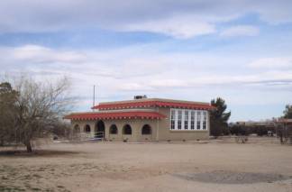
Goffs School |
|
| The Goffs School was built in 1914 and served the outlying families of the area from 1914 through 1937. It was a survivor of old Route 66. The old school was certainly not what I had expected. Instead of the usual wood frame construction found in remote desert communities, it was constructed of a heavy wood frame, steel mesh and stucco. I had a preconceived idea of what an old school should look like, and the Goffs School didn't meet those expectations. The unique mission style architecture of the school seemed oddly out of place here. |
|
 |
I glanced at the picture of the school as it was in 1982 and saw just how far the school had deteriorated over the years. The roof was falling in, and the windows and frames were missing. In my opinion it could have qualified for "ruin status". The job of restoration by the Mojave Desert Heritage and Cultural Association must have been a big one indeed. They really did a fine job of it too. The school in front of me that Sunday morning looked identical to the 1914 picture of it. It was clean and crisp with none of the weathering evident from the years of neglect. It looked brand new and ready to open its doors once again to the students of Goffs. |
| I'm glad that dedicated people took it upon themselves to preserve a part of our heritage for future generations. The Goffs schoolhouse is now quite functional again and is being used as a museum and the headquarters for Friends of the Mojave Road. |
|
Goffs East Mojave Cultural Center |
||||
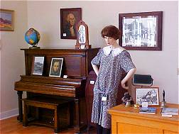
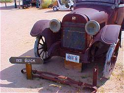
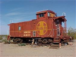
| There's a lot more to see and do at the Goffs School too. The Mojave Desert Heritage and Cultural Association has extensive archives, maps and photographs of the area for the study of the Mojave's fascinating history. They have also saved and recreated a whole town behind the school house as a great open air exhibit on life in the Mojave Desert. From mining exhibits with real structures and equipment to Route 66 memorabilia this is a must see stop for any history buff. In many ways I was reminded of what Knott's Berry Farm must have looked like when it first got started back in the 1950s. | ||||
 |
|
|
||
| The Goffs' East Mojave Cultural Center celebrates Route 66. After all Route 66 once passed through the property as evidenced by the remains of pavement found at the center. Travel through the Mojave desert was always regarded with dread and I'm sure this small slice of Route 66 at Goffs saw its own share of human drama over the years it was part of Route 66. | ||||
Cultural Center exhibits remind one of the early days of automobile travel through the Mojave Desert. The Friends of the Mojave Road have managed to save and preserve a piece of this history to be enjoyed by generations to come. |
|
|||
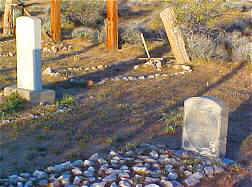 |
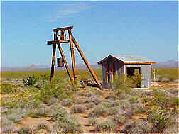
All facets of life in the Mojave, and yes, even death are preserved at Goffs. The old Goffs graveyard is silent evidence of that. |
|||
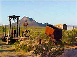 |
Mining played a dominate role in the early years of Mojave settlement. Goffs East Mojave Cultural Center has an extensive collection of equipment salvaged from the area mines. |
|
||
 |
This wonderful oasis in the Mojave Desert at Goffs was the dream of Dennis Casebier. Dennis and his wife JoAnn have worked long and hard to bring their dreams to fruition. What makes this place extra special is that all the work has been done by dedicated volunteers. The East Mojave Cultural Center has received no grants from the Federal or State Government. They survive wholly on donations and the hard earned sweat of committed preservationists. Many of them spend their vacation time working at the East Mojave Cultural Center! The Cultural Center is open to visitors the first weekend in every month. If you happen to be coming through at that time you owe it to yourself to stop and explore this unique and educational place. But remember, you can't enjoy Goffs fully in less than an hour. Plan to spend some time here. | |||
Photographs taken January, March 2001 & May 2003
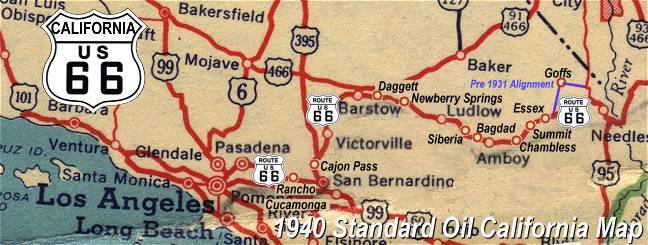
Click on an area or city of Route 66 on the map below to take a cyber tour of that section of the Mother Road |
|
|
NAVIGATION NOTE: Buckle up and hold on to your mouse! These pages are arranged like the map above, Pacific Ocean being West Route 66 and the Colorado River East Route 66. I have set up this site as if you were traveling from EAST to WEST, much like the Joad family in The Grapes of Wrath. You can click on the Route 66 shields to "travel" the Mother Road in either direction though. Clicking West Route 66 or East Route 66 will take you to the next town or area on the map in that direction. Or you can select any shield below to take you to that specific state. |
|
To Mojave Outposts |
To Needles |

© Copyright 2003 GRandall Web Design Service