 |
The Colorado River |
|
[HOME] [WESTERN AMERICANA GALLERY] [ROUTE 66 HOME] [ROUTE 66 WEST] [ROUTE 66 EAST]
|
The Colorado River |
|
| The Colorado River Crossing | |
| It's about twenty five miles from Oatman to the town of Topock on old Route 66. Just a short distance from Topock is the Colorado River. Route 66 crosses under the Santa Fe Railroad Bridge and rejoins the Interstate once more. At this point I-40 crosses the Colorado River and enters California. | |
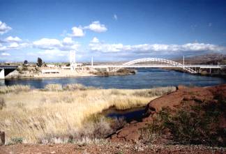
| The old 1947 Red Rocks Bridge, which once carried the Route 66 traveler across the Colorado, has long since disappeared. It was abandoned in 1966 when I-40 replaced it, and was torn down in 1976. The Red Rock Bridge was built over an old AT&SF Railway right of way because it was wider than the earlier steel arch bridge. Off in the distance I could see the original steel arch bridge: the bridge of the Grapes of Wrath days. This was the bridge that had carried the dust bowl immigrants to the promise of a new life in California. The old Trails Arch Bridge, as it was called, carried traffic across the river from 1916 until the newer Red Rock Bridge was opened. |
|
|
It was abandoned after the new bridge opened, and was converted to support a gas line across the Colorado River. It is still used for this purpose today. I had been under this bridge many times in the late 80's and early 90's with Coast Guard Patrol Boats on our way up the Colorado River to Park Moabi or Needles. At that time I really didn't realize the historical significance of the bridge, I just knew it was old and kinda neat. |
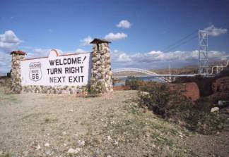
| I took the Park Moabi exit off I-40. I wanted to retrace my path back to the California side of the Colorado River; this time following Route 66. When I came to Park Moabi I made a right turn onto National Trails Highway and proceeded to follow the old road towards the river. After passing under the railroad bridge and I-40 the old road ended at the Colorado River and the old Historic 66 Billboard. This billboard once advised travelers that they were about to enter Arizona and to "Breathe Deeply Folks." Today it advises travelers on the Interstate to turn right at the next exit for Historic Route 66. |
|
|
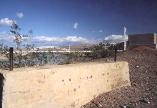
Near the billboard are the remains of concrete footings, all that are left of the Red Rock Bridge. This is a beautiful spot on the Colorado River and affords a good view of the old Trails Arch Bridge spanning the river. It was a nice place to reflect on the old road as I watched the boat traffic pass under the old bridge on the way down river to Lake Havasu. The old road exists as a shadow at this place, the concrete bridge footings offer only the barest hint of what once was the gateway to Golden California and the shores of the Pacific Ocean. |
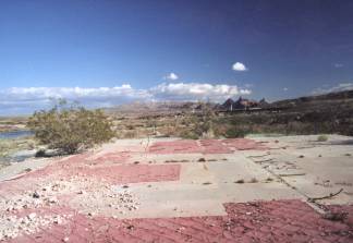
| Heading back towards Park Moabi, off to my left I saw a clearing and driveway going up a little hill. At the top of the hill I found the ruins of the Workman's Cafe. All that is left is a foundation with some sun blasted tiles curling up from the concrete slab. From the pattern of the tiles I could see where the counters and booths once stood. As I looked at the empty foundation I wondered how many travelers must have occupied that space in another time. It was quiet on that hill now with only the wind as my companion. A small gust brought the few scrubby bushes to life and they danced impatiently as if waiting for the day when the desert would completely reclaim this hill as its own. |
|
Colorado River Resorts |
|
| During the late 1950's and early 1960's the Colorado River near Route 66 underwent a land rush so to say. Lake Havasu City was founded a few miles south of Route 66 in 1963 and probably was the most successful of these new retirement and resort towns on the Colorado River. The London Bridge is even located in Lake Havasu City now! This vintage post card shows another promising resort up river from Route 66. The Colorado River is a popular destination even today for winter visitors seeking to come to a warmer climate. | 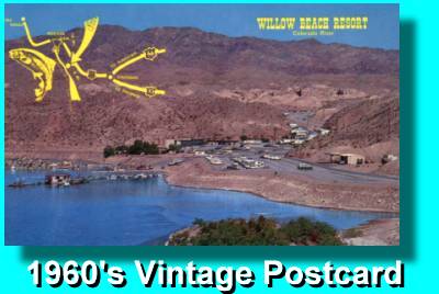 |
Photographs taken March 2001
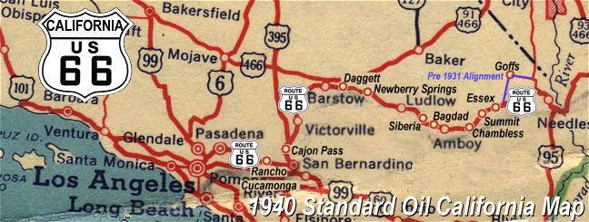
Click on an area or city of Route 66 on the map below to take a cyber tour of that section of the Mother Road |
|
|
NAVIGATION NOTE: Buckle up and hold on to your mouse! These pages are arranged like the map above, Pacific Ocean being West Route 66 and the Colorado River East Route 66. I have set up this site as if you were traveling from EAST to WEST, much like the Joad family in The Grapes of Wrath. You can click on the Route 66 shields to "travel" the Mother Road in either direction though. Clicking West Route 66 or East Route 66 will take you to the next town or area on the map in that direction. Or you can select any shield below to take you to that specific state. |
|
To Needles |
To Arizona
|

© Copyright 2003 GRandall Web Design Service