 |
Route 66 in the
|
|
[HOME] [WESTERN AMERICANA GALLERY] [ROUTE 66 HOME] [ROUTE 66 WEST] [ROUTE 66 EAST]
|
Route 66 in the
|
|
Needles, California - Hub of the Mojave Desert |
|
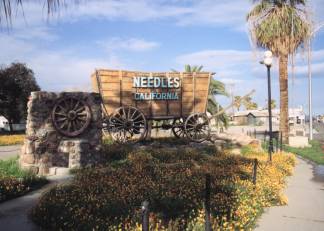 |
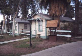
Route 66 joins the Interstate at Park Moabi and heads west towards Needles. A few miles down I-40 I took the Five-Mile Station Road exit to get back on Route 66 and enter Needles on Front Street. As I entered Needles I saw the famous Welcome to Needles Covered Wagon and across the street was the Palms Motel. I was pleasantly surprised. I'm not sure what I expected but it certainly wasn't this nice little oasis in the desert. The Palms Motel was clean; the well-kept cabins were surrounded by a manicured lawn and garden and looked like they had a fresh coat of paint on them. |
| What a pleasure it was to see a part of Route 66 history preserved so well. As I walked up to the little office I met a resident of the motel standing outside enjoying the late afternoon sun. A pick up truck pulled into the driveway. I was about to meet the owner of the Palms Motel, Luis Bravo. We started talking about Route 66, the history of the area and preservation along the old road. Luis was justifiably proud of this great old 1920's motor court. He lovingly described the work he had done and the other projects he hoped to accomplish in the future. Standing there under the shade of the palm trees talking to Luis I could see he was very serious about preserving this little piece of Route 66. All too soon it was time to go. I needed to find a place to stay for the night. Luis thought there were some motels up the road but wasn't sure if they were open or not. I was about to find out. Back in my car I pulled out onto Route 66 once more, this time I was looking for a place to stop for the night. | |
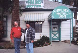 |
 Luis Bravo (right) with resident of the Palms Motel in Needles. |
|
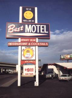
I drove old Route 66 through downtown Needles. The traffic was light on this Saturday afternoon and I could plainly see the Route 66 Shields stenciled on the road. I was glad they were there. This was a new stretch of road for me and those stencils kept me on track. I passed a couple of motels. One motel was definitely open but others appeared closed and run down. I even passed one that looked like it was in the process of being torn down. Then up ahead on my right I saw a motel that looked promising. That it was a Route 66 motel was evident, though it appeared to be from a later era. The architecture suggested it was built in the 1950's. . I pulled into the parking lot of the Best Motel in Needles, California. |
| The rates were quite reasonable and I soon had the key for my room. As I was talking to Robert the assistant manager (his wife was the manager) another gentleman walked in. We had been talking about Route 66 and I had asked about the history of the motel. The other gentleman was Dan Meister and he was more than happy to fill me in on some of the motel's history. Seems this was an old Travel Lodge that was built around 1952. |
|
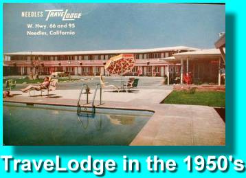 |
Dan even had a photograph of a post card of the Travel Lodge taken around 1955. When I expressed an interest in using a picture of the old post card on my web site he promised to send me an e-copy. True to his word, I received it a few days later. After I had settled into my room, I decided to check out the Hungry Bear for dinner; I made the right decision. The Route 66 motif and memorabilia in the restaurant, plus the good food provided the perfect end to my first day on the road. |
|
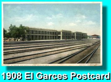
Sunday morning was beautiful. What a great day to continue my explorations of Route 66. I was in excellent spirits as I set off to find the Needles train station. I wound up in downtown Needles and parked my car at the El Garces Harvey House and Santa Fe Depot. The structure was undergoing massive restoration at the time and I must admit I was happy to see the city taking the project seriously. |
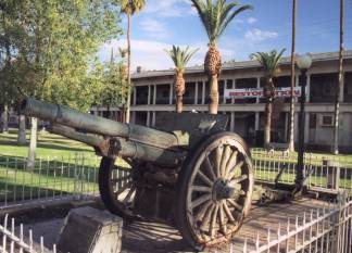
| "If you want to see what it really looked like in its prime
you ought to go to the Library. They have old pictures of it there." I turned to see
a lady watching me curiously. "Thanks," I said. "It really is quite a structure, I'm sure glad to see they're restoring it. So much of our historical heritage is being lost. They seem to be doing a good job of restoration by the look of it. I'm glad the city didn't decide to tear it down." "I don't think the city wanted to tear it down. It would have been too much work for them." she laughed. "See those pillars over there?" she asked. "Well when they built the station they used regular iron rails from the tracks for the concrete support. I've heard those rails support the whole darn station. I think they just figured it would be easier to restore it than tear it down." she smiled. |
|
|
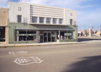
"Route 66 ran right along this street." she said. There's the Needles Regional Museum across the street. That building used to be the J.C. Penny's store, and see that vacant lot across the street from it? The Needles Hospital used to be there, in fact I have a cousin that was born in that hospital back in the 50's." For a moment her eyes reflected a far off look, as she recalled those special moments from her past. All too soon the spell was broken as she came back to the present. |
| "Oh, I'd better get to work or I'll be late." she said with the nod of her head. "It was nice to meet you, and good luck with your Route 66 pictures." and then she was off down the street. A few more pictures and I'd better be off myself I thought. I had a brand new stretch of Route 66 ahead of me to explore. | |
Take a Route 66 Sidetrip to the El Garces Depot: |
|
Photographs taken March 2001
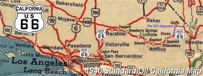
Click on an area or city of Route 66 on the map below to take a cyber tour of that section of the Mother Road |
|
|
NAVIGATION NOTE: Buckle up and hold on to your mouse! These pages are arranged like the map above, Pacific Ocean being West Route 66 and the Colorado River East Route 66. I have set up this site as if you were traveling from EAST to WEST, much like the Joad family in The Grapes of Wrath. You can click on the Route 66 shields to "travel" the Mother Road in either direction though. Clicking West Route 66 or East Route 66 will take you to the next town or area on the map in that direction. Or you can select any shield below to take you to that specific state. |
|
To Goffs |
To the Colorado River |

© Copyright 2003 GRandall Web Design Service